Picture |
Object
name
#NORAD |
Description |
Launch
Date |
Weight |
|
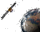
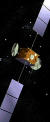
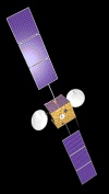
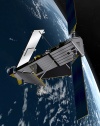
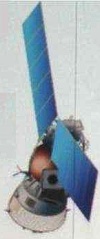
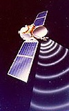
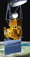
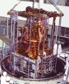
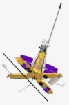
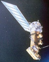
INMARSAT
3F1
I3F1
IOR
#23839
(1996-020A) |
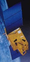
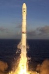
Inmarsat I-3 F1 was the
first of the third generation Inmarsat satellites. It
was launched in 1996 on an Atlas-2A rocket to cover
the Indian Ocean Region. It was finally placed in a
geostationary orbit at 64° East. Its communication
system include 22(+11) L-band transponders (22W power
amplifiers) and a C-band uplink. |
April
3rd 1996 |
2068
kg |
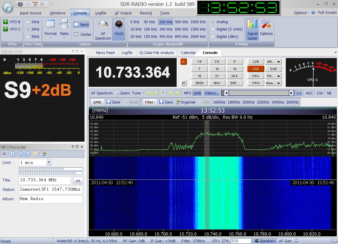
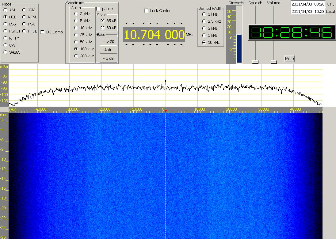
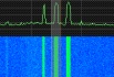
  Enclosed
audio signal was received on April 30th
2011 at 13:52 UTC on 1547.730 MHz. Many thanks to Greg
Roberts for kindly providing this recording. Enclosed
audio signal was received on April 30th
2011 at 13:52 UTC on 1547.730 MHz. Many thanks to Greg
Roberts for kindly providing this recording.
|
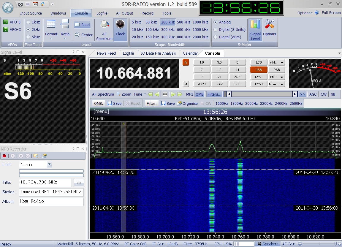
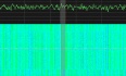
 Enclosed
audio signal was received on April 30th
2011 at 13:56 UTC on 1547.550 MHz. Many thanks to Greg
Roberts for kindly providing this recording. Enclosed
audio signal was received on April 30th
2011 at 13:56 UTC on 1547.550 MHz. Many thanks to Greg
Roberts for kindly providing this recording.
|
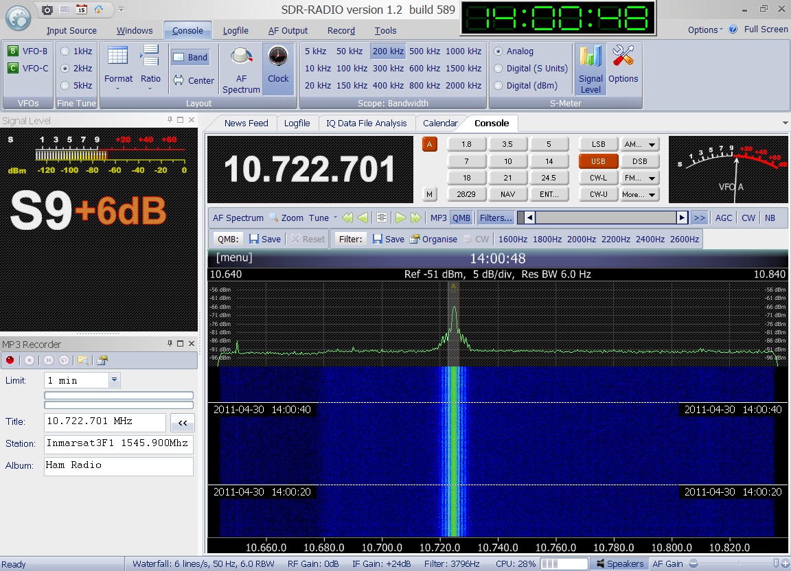
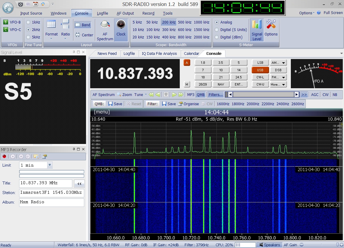
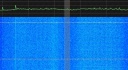
 Enclosed
audio signal was received on April 30th
2011 at 14:00 UTC on 1545.900 MHz. Many thanks to Greg
Roberts for kindly providing this recording. Enclosed
audio signal was received on April 30th
2011 at 14:00 UTC on 1545.900 MHz. Many thanks to Greg
Roberts for kindly providing this recording.
|
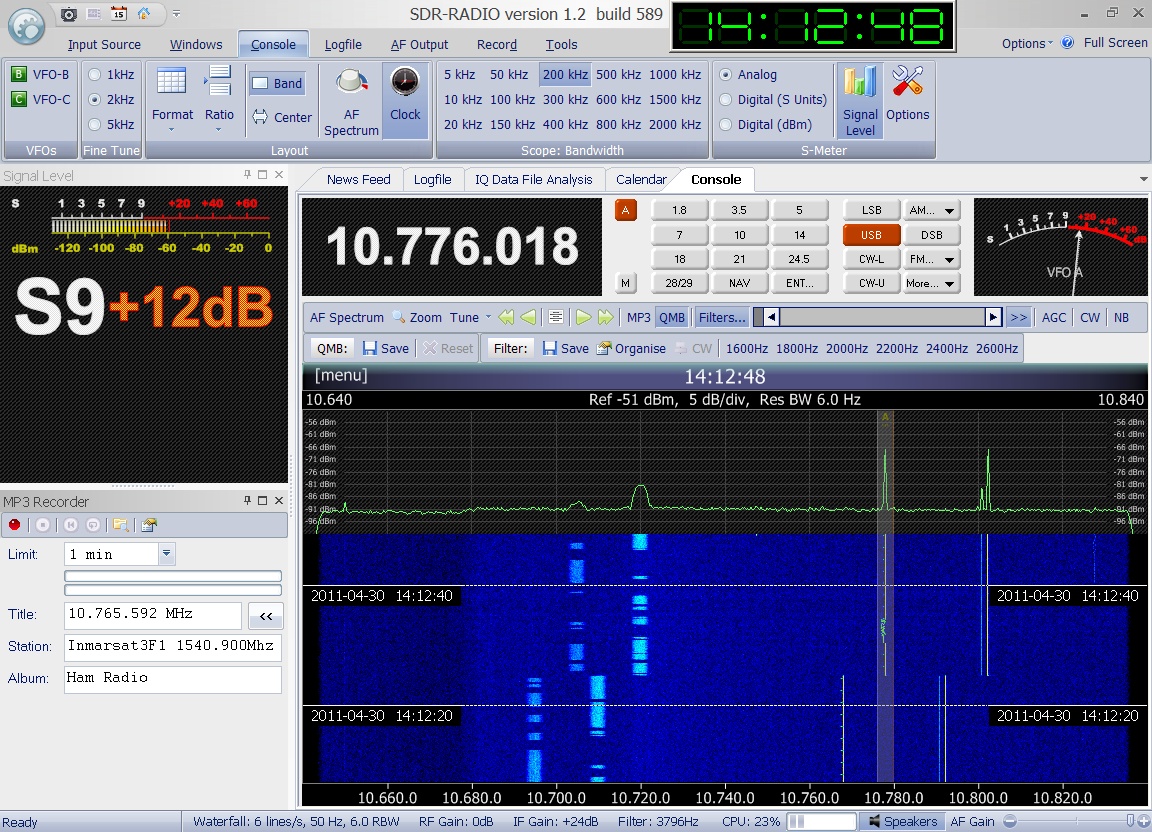
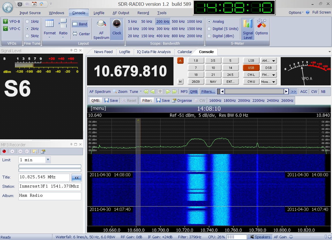
 Enclosed
audio signal was received on April 30th
2011 at 14:12 UTC on 1540.900 MHz. Many thanks to Greg
Roberts for kindly providing this recording. Enclosed
audio signal was received on April 30th
2011 at 14:12 UTC on 1540.900 MHz. Many thanks to Greg
Roberts for kindly providing this recording.
|
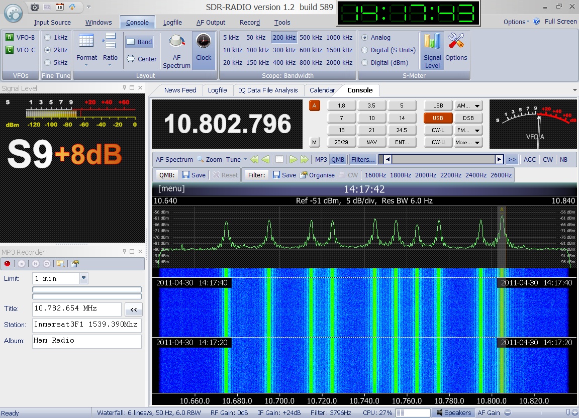
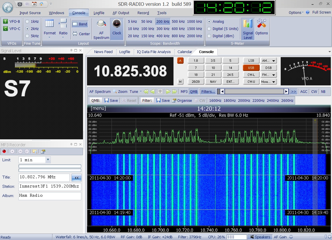
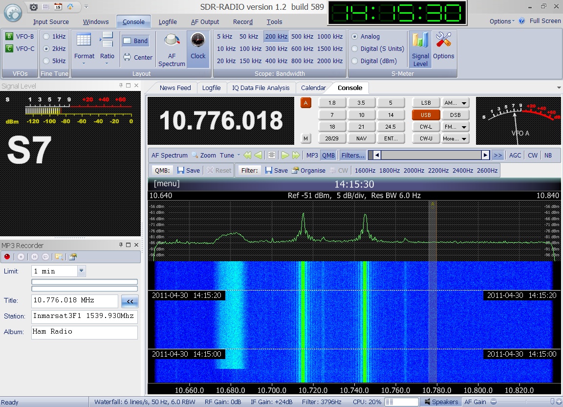
 Enclosed
audio signal was received on April 30th
2011 at 14:17 UTC on 1539.390 MHz. Many thanks to Greg
Roberts for kindly providing this recording. Enclosed
audio signal was received on April 30th
2011 at 14:17 UTC on 1539.390 MHz. Many thanks to Greg
Roberts for kindly providing this recording.
|
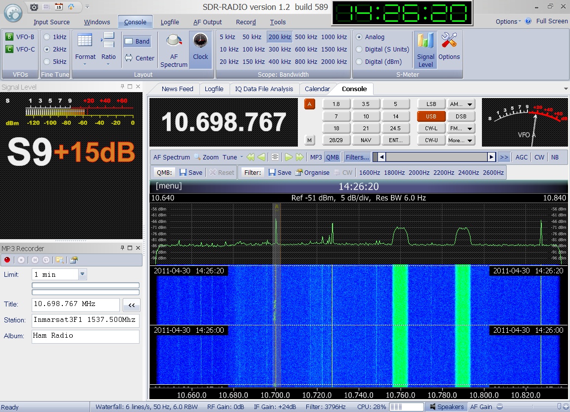
 Enclosed
audio signal was received on April 30th
2011 at 14:26 UTC on 1537.500 MHz. Many thanks to Greg
Roberts for kindly providing this recording. Enclosed
audio signal was received on April 30th
2011 at 14:26 UTC on 1537.500 MHz. Many thanks to Greg
Roberts for kindly providing this recording.
|
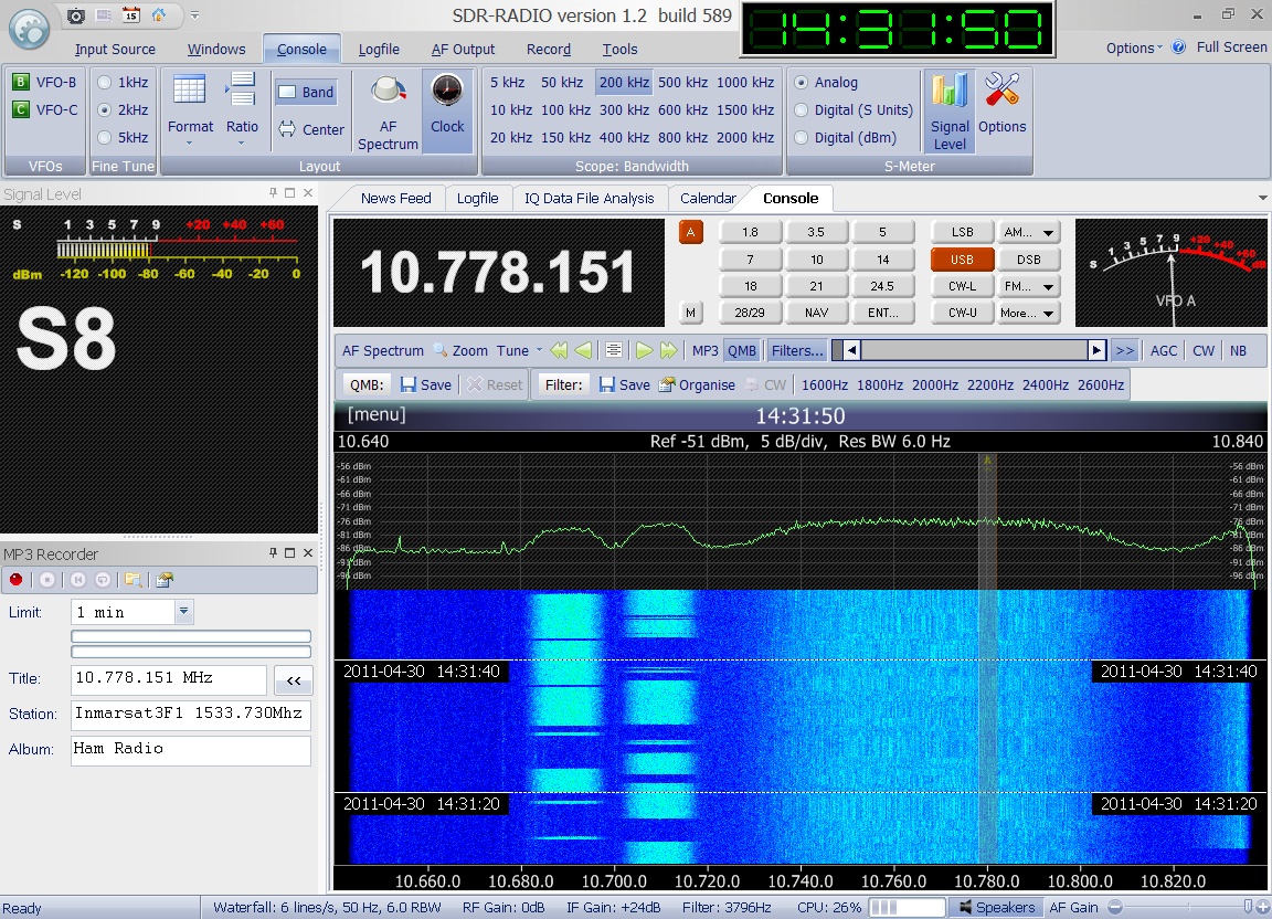
 Enclosed
audio signal was received on April 30th
2011 at 14:31 UTC on 1533.730 MHz. Many thanks to Greg
Roberts for kindly providing this recording. Enclosed
audio signal was received on April 30th
2011 at 14:31 UTC on 1533.730 MHz. Many thanks to Greg
Roberts for kindly providing this recording.
|
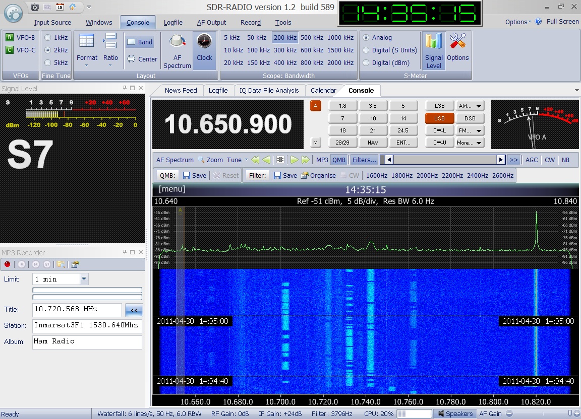
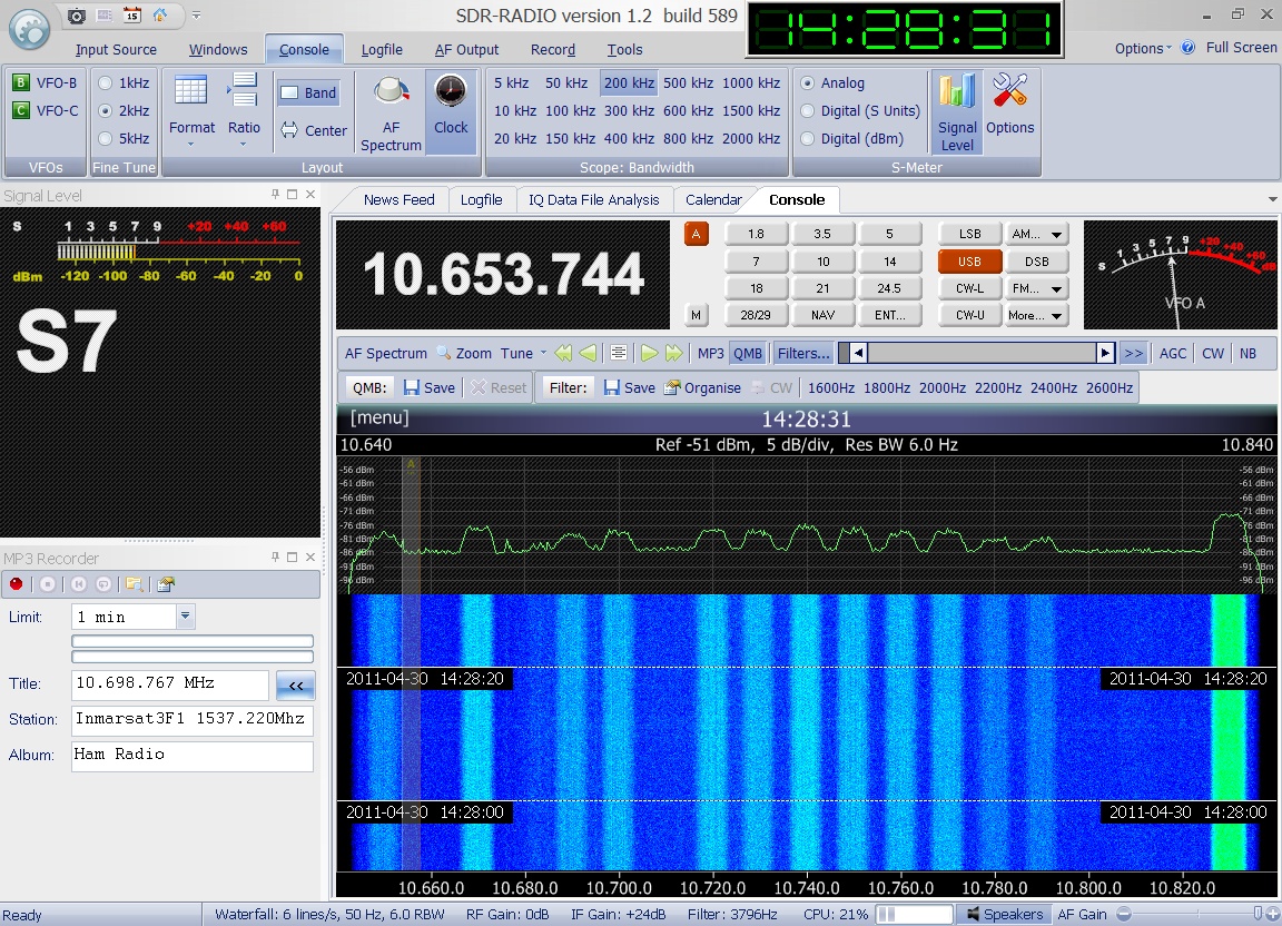
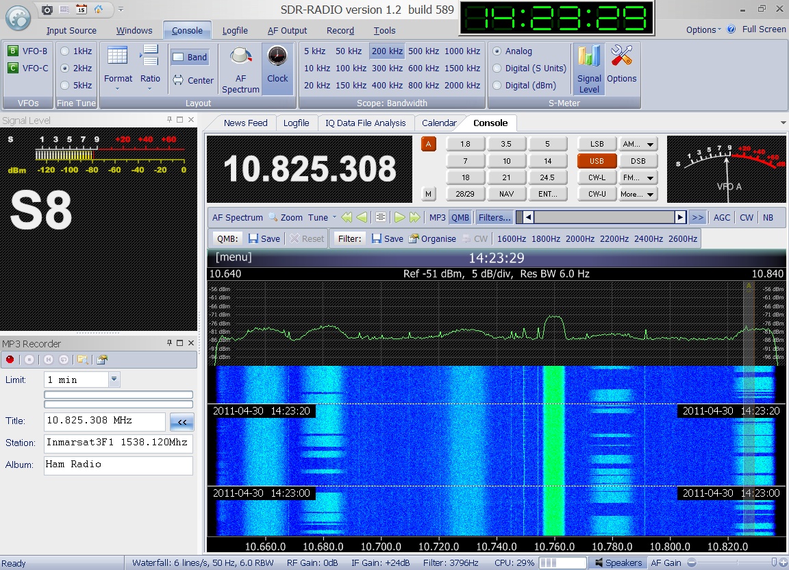
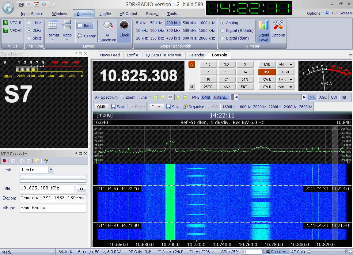
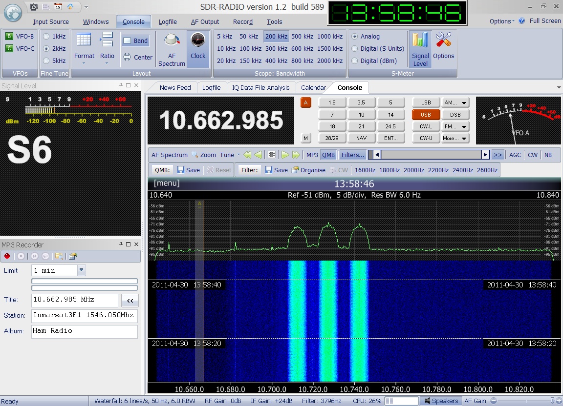
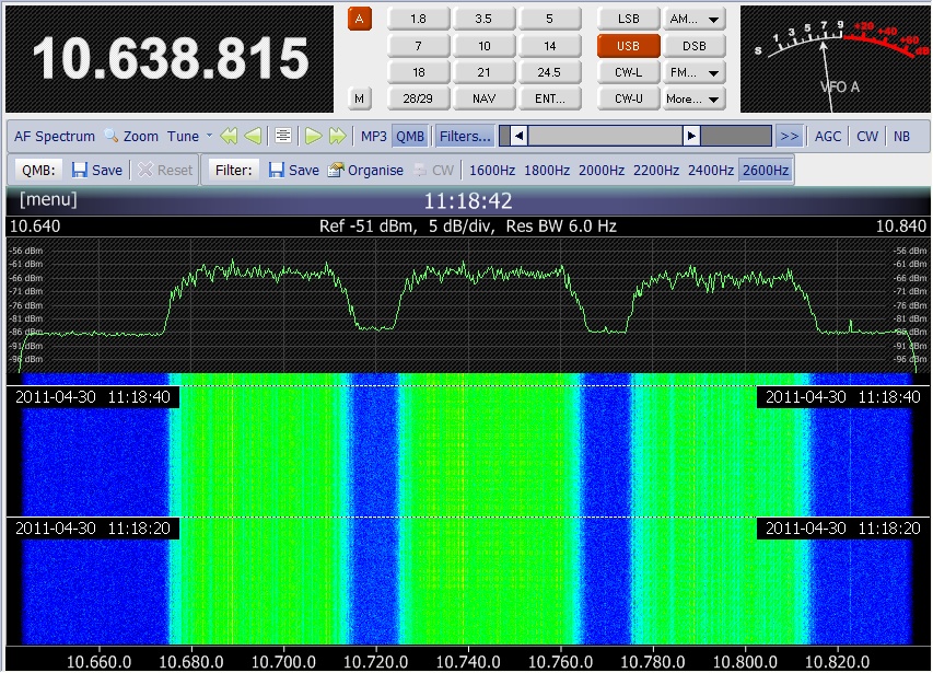
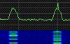
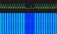
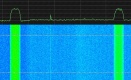
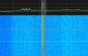
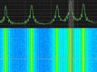
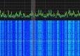
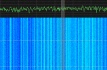
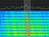
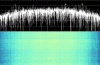
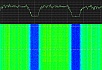
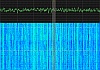
Its is amazing, how different
the various signals on the Inmarsat 3F1 transponders
are. Enclosed please find some more spectrum plots taken
on April 30th 2011 by Greg
Roberts.
         |
|
UFO
7
UHF-FO 7
USA 127
#23967
(1996-042A) |
UFO 7
(Ultra High Frequency Follow On) is a geostationary
(25°W) military communications satellite. It carries
39 UHF channels with a total bandwidth of 555 kHz, a
SHF subsystem, 20 EHF channels. Recorded on Jan 5th
2008 on 249.125 MHz in LSB by Chris Gross in Pennsylvania
using a Yupiteru MVT-7100. |
Jul
25th 1996 |
3015
kg |
Recorded
on Jan 5th 2008 on 267.035
MHz in LSB by Chris Gross in Pennsylvania using a Yupiteru
MVT-7100. |

|
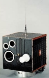
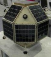
MUSAT-1
MO30
Microsat
#24291
(1996-050A) |
MuSat
- 1 "Victor" was developed and built by a
25-person team at the Instituto Universitario Aeronautico,
under the Sponsorship of the government of the province
of Cordoba. MuSat-1 was launched together with Magion-5
and Prognoz M-2 by a Molniya-M rocket from Plesetsk
cosmodrome. It was the first satellite made in Argentina
and the 340x340x450mm Microsat was reported to be functional.
"Victor " is an experimental vehicle, intended
to evaluate in-orbit behavior of low-cost space technologies.
It carries two video cameras, oriented for earth-imaging,
as well as transceivers in both UHF and S bands. Electrical
power is provided by four 88-Si cells solar panels,
with an end-of-life electrical power of 8W. It finally
decayed on the November 12th
1999.
The recorded beacon, which can be heard every
90 seconds on 137.95 MHz as a brief burst of CW "Hi
hi de MUSAT", was provided by Dale Ireland. |
Aug
29th 1996 |
32
kg |
MUSAT-1
transmits a tone-modulated Morse-code signal which
is a burst of CW code of approx. 7 seconds in duration,
repeated every 90 seconds. It starts with: "HI
HI DE MUSAT....". This signal was received on 137.95
MHz on Jan 12th 1997 around 14:45
UTC by Sven Grahn. |

|
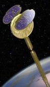
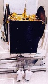
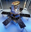
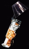
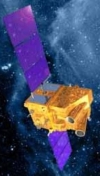
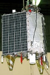
INMARSAT
3F2
I3F2
AOR-E
#24307
(1996-053A) |
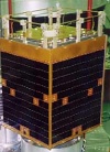
Inmarsat 3F2 was built
by Lockheed Martin and is based on their GE-4000 platform.
It was launched without a apogee kick motor from Baykonur
on a Proton-K/DM-1 launcher (#243) and was thus directly
injected into a GSO. It geostationary orbit position
was finally at 15.5° West.
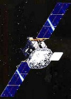
Inmarsat 3-F2s primary mission is
to supply voice and data communications services worldwide
to mobile terminals such as small as pocket-size messaging
units on ships, air-crafts and vehicles. It can dynamically
reallocate both RF power and bandwidth among a global
beam and seven spot-beams, allowing greater reuse of
the available spectrums. The spot-beams are directed
as required to make extra communications capacity available
in areas where demand from users is high. Its main transponder
is an L-Band transponder (1.6/1.5 GHz) using two 2m
big dish based circular polarized antennas for up- and
down-link. You can see the 2 dishes in the lower left
picture. EIRP on L-Band is up to 48dBW. Its forward
bandwidth is 29 MHz, its return bandwidth is 39 MHz.
In addition it features a C-Band transponder (6.4/3.6
GHz) also using circular polarized antennas Its bandwidth
there is 39 MHz.
Furthermore I3F2 is also part of
the EGNOS satellite based augmentation system (SBAS).
Its carries a navigation transponder designed to enhance
the accuracy, availability and integrity of the GNSS
(GPS and Glonass) global navigation satellite systems. |
Sept
6th 1996 |
1150
kg |
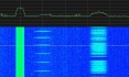
Enclosed
audio signal was received on April 7th
2011 at 13:55 UTC from one of the paging channels of
Inmarsat 3F2. It is a slow MFSK signal. Many thanks
to Greg Roberts for kindly providing this recording. |
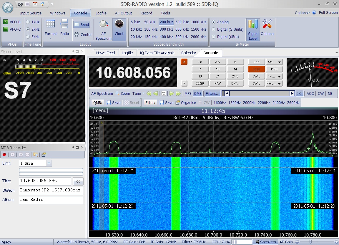
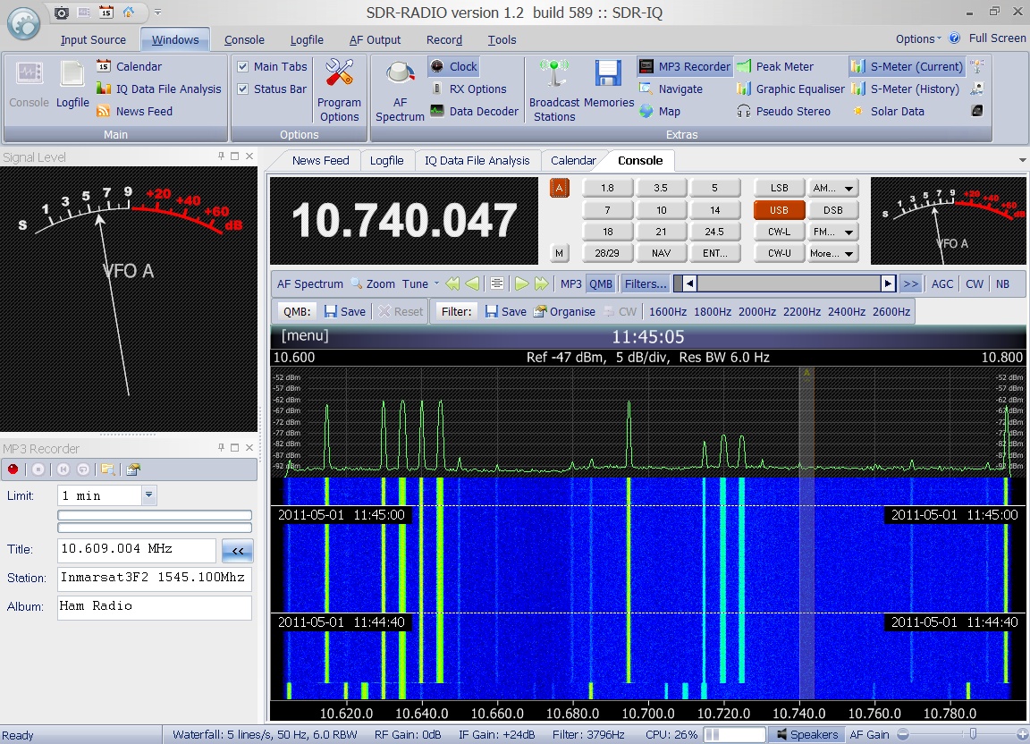
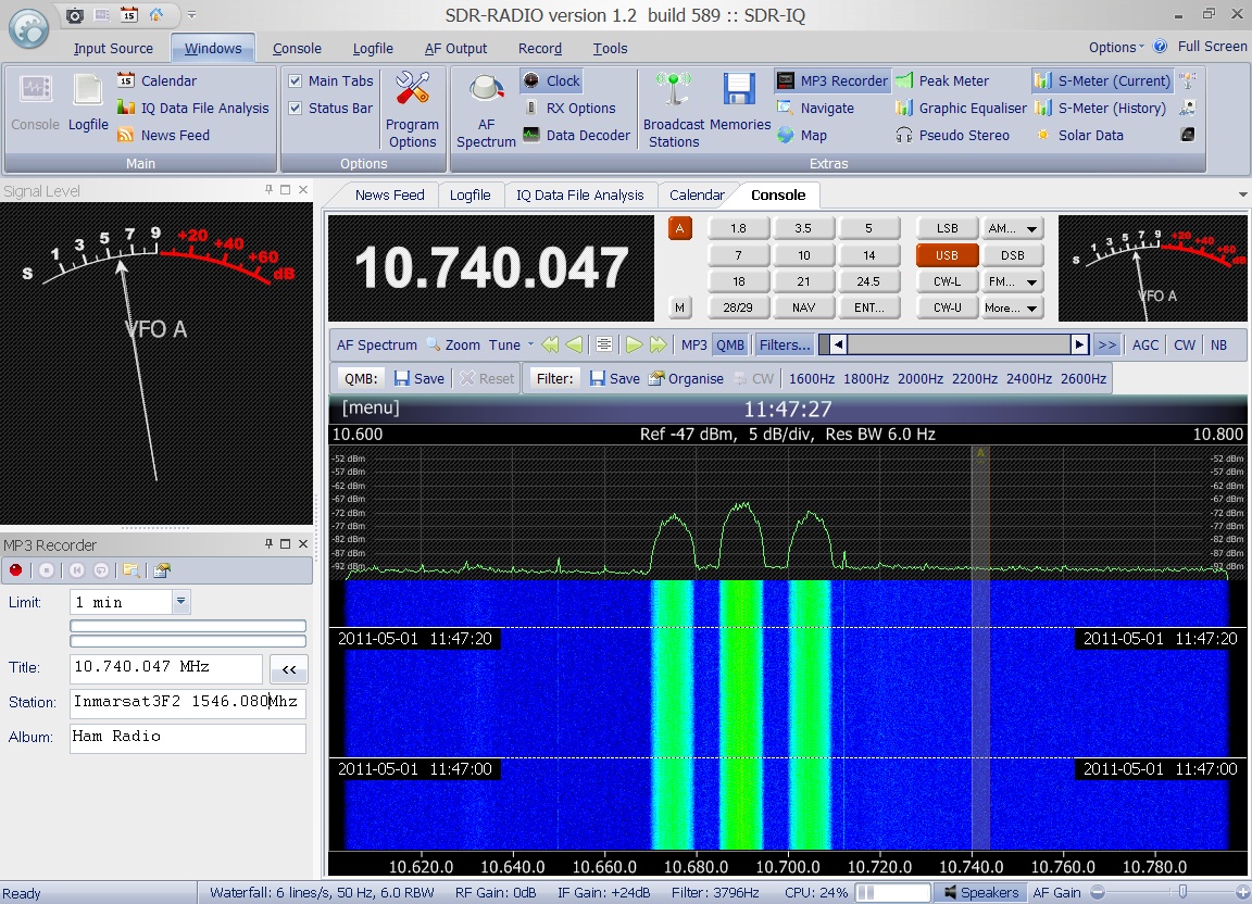
 Enclosed
audio signal and associated spectrum plot was recorded
by Greg Roberts on May 1st
2011 at 11:12 UTC on 1537.630 MHz. Enclosed
audio signal and associated spectrum plot was recorded
by Greg Roberts on May 1st
2011 at 11:12 UTC on 1537.630 MHz.
|
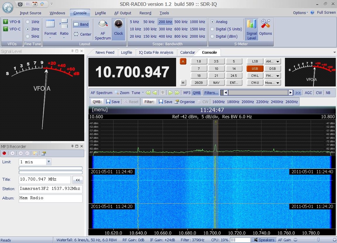
 Enclosed
audio signal and associated spectrum plot was recorded
by Greg Roberts on May 1st
2011 at 11:24 UTC on 1537.932 MHz. Enclosed
audio signal and associated spectrum plot was recorded
by Greg Roberts on May 1st
2011 at 11:24 UTC on 1537.932 MHz.
|
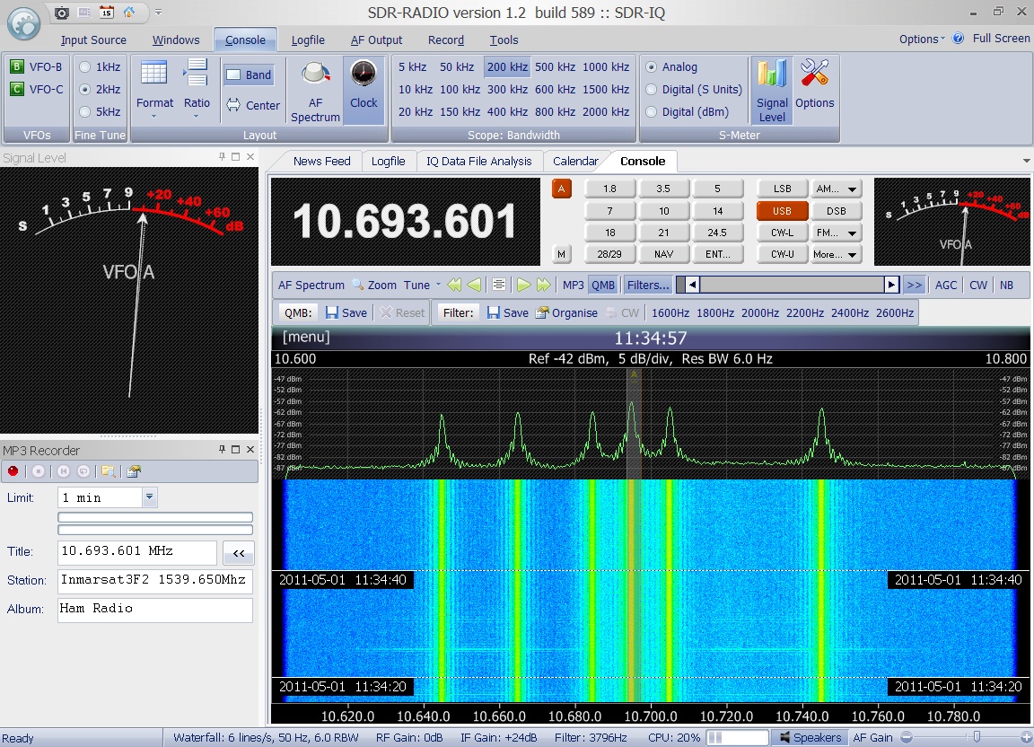
 Enclosed
audio signal and associated spectrum plot was recorded
by Greg Roberts on May 1st
2011 at 11:34 UTC on 1539.650 MHz. Enclosed
audio signal and associated spectrum plot was recorded
by Greg Roberts on May 1st
2011 at 11:34 UTC on 1539.650 MHz.
|
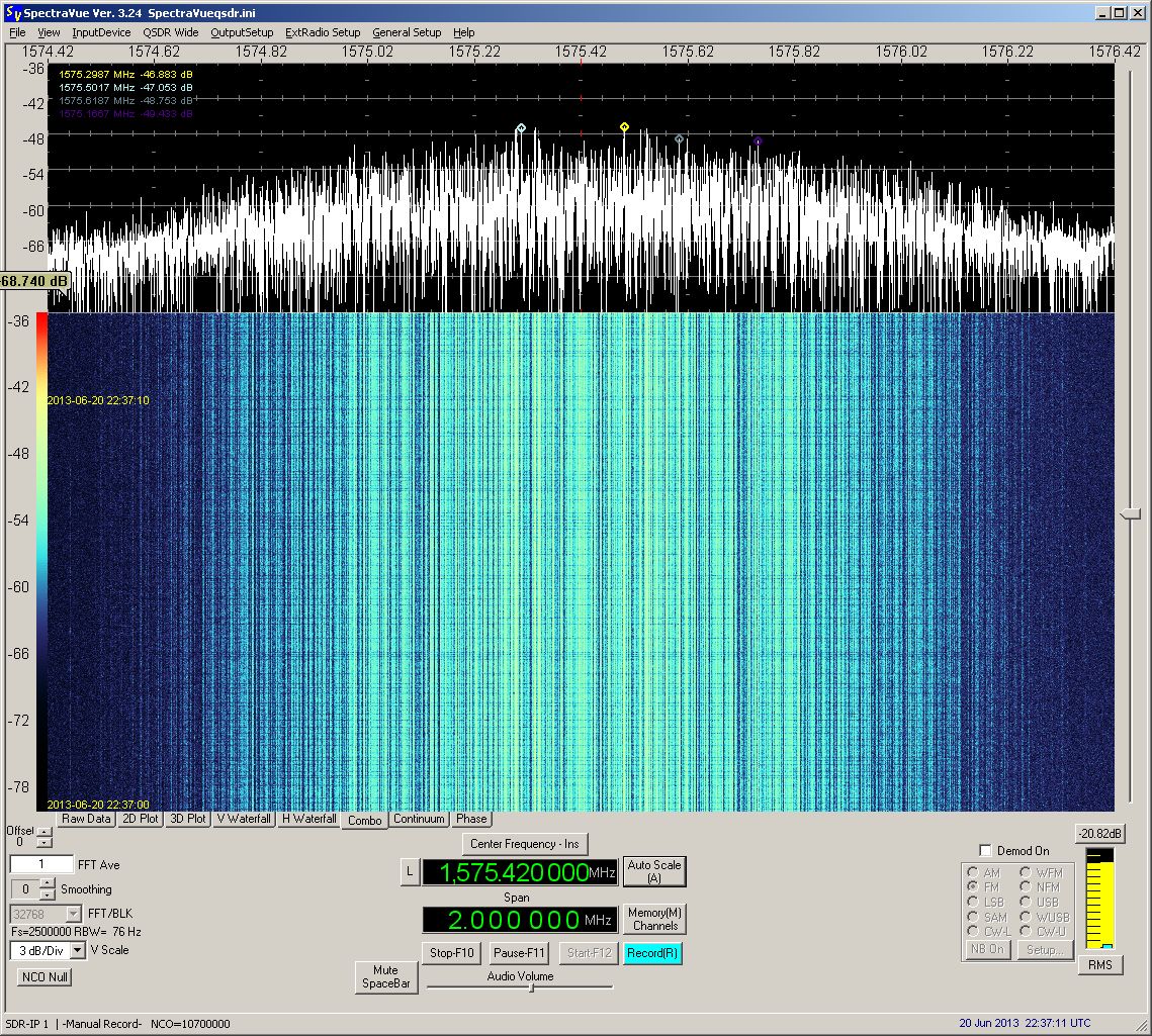
 Enclosed
audio signal and associated spectrum plot was recorded
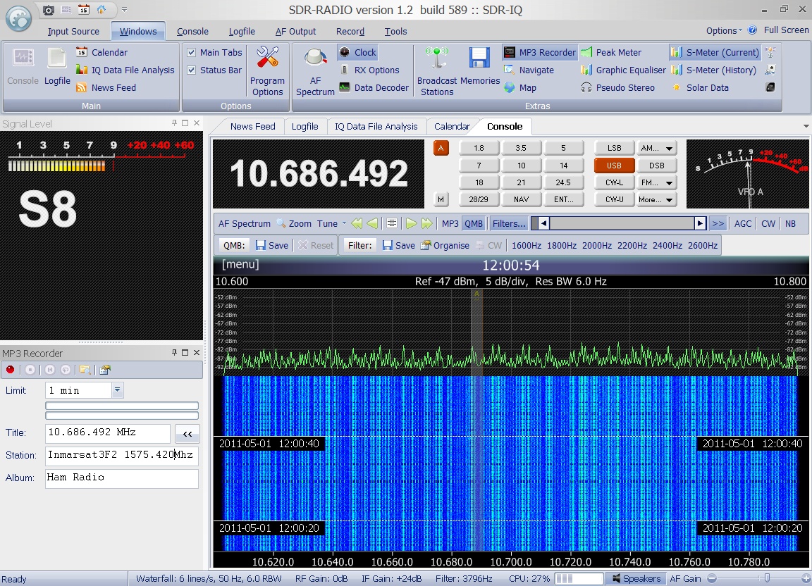
by Greg Roberts on May 1st
2011 at 12:00 UTC on 1575.420 MHz. Enclosed
audio signal and associated spectrum plot was recorded
by Greg Roberts on May 1st
2011 at 12:00 UTC on 1575.420 MHz.
|
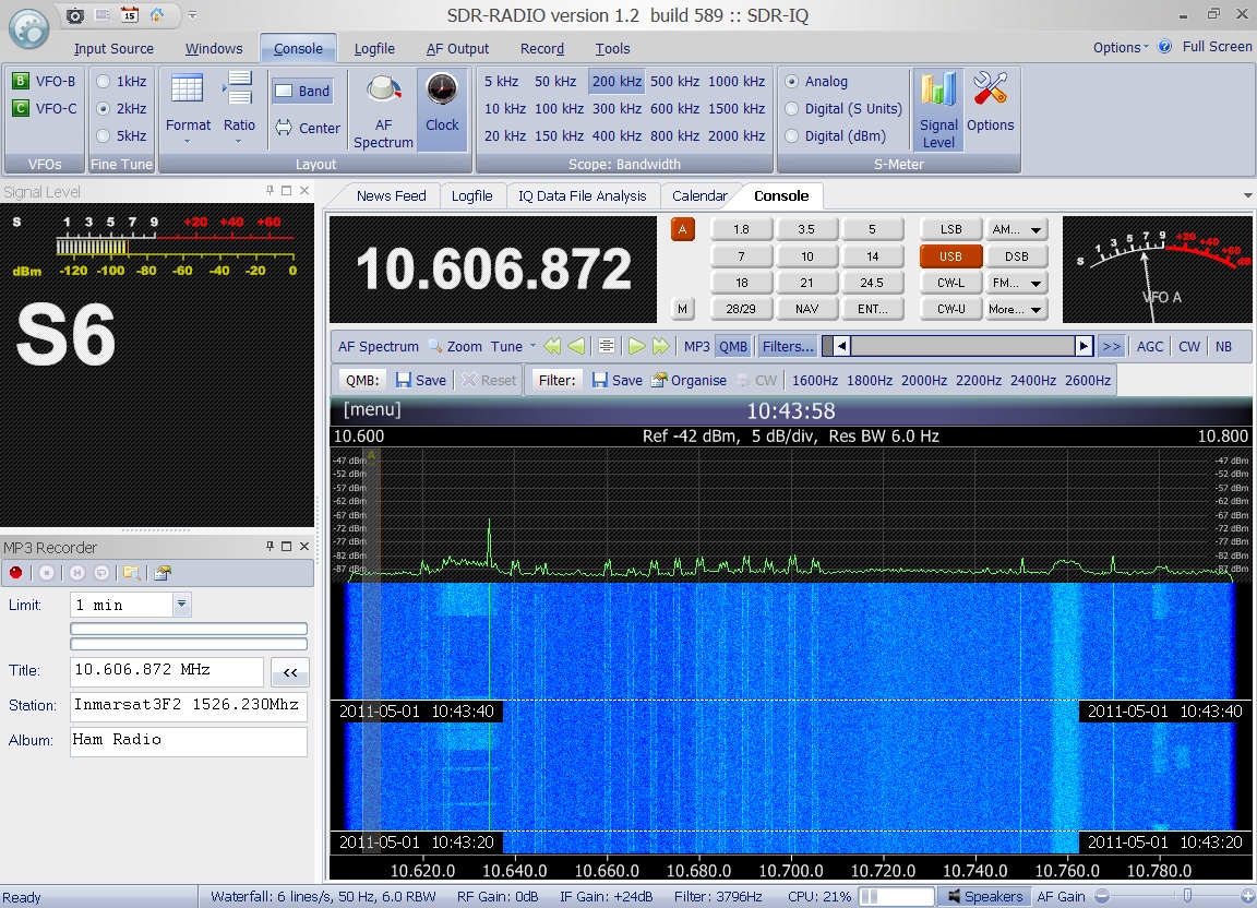
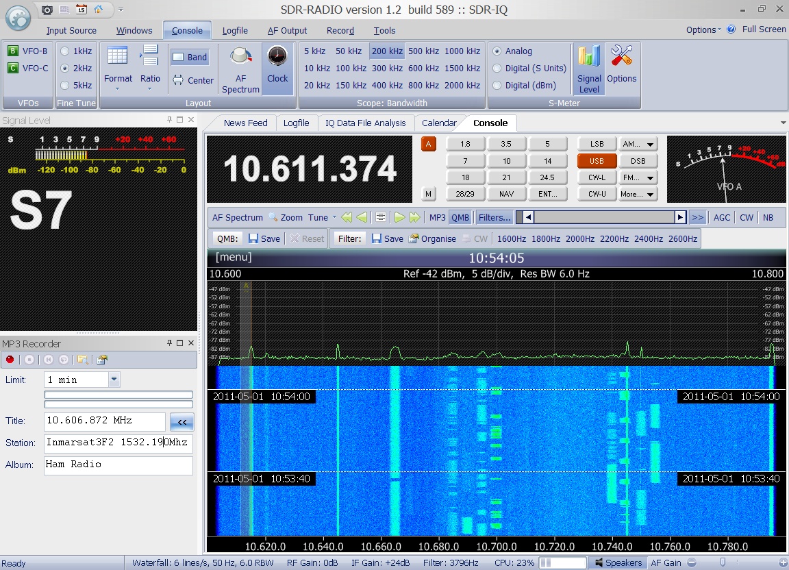
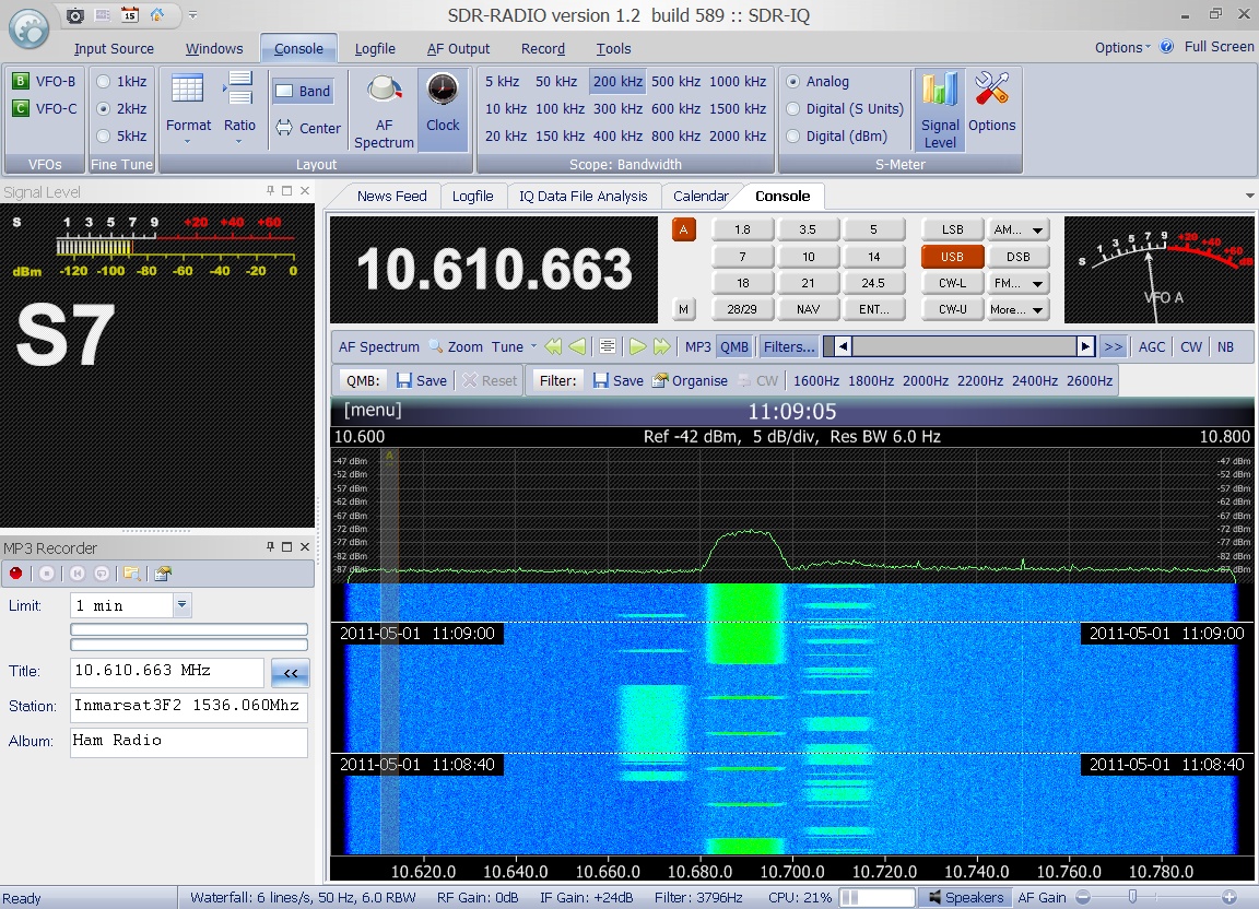
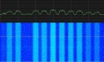
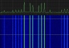
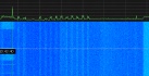
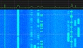
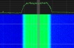
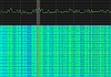
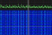
Its is amazing, how different
the various signals on the Inmarsat 3F2 transponders
are. Enclosed please find some spectrum plots each of
them being 190kHz wide and taken all by Greg Roberts
on May 1st 2011.
         |

|
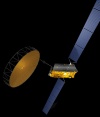
Iridium
8
#24792
(1997-020A) |
The IRIDIUM satellite
system provides worldwide voice and data coverage including
remote areas. When a subscriber is in a remote area
his handset will operate through the satellite network
whereas it will use terrestrial networks wherever available.
The satellite system is based on 66 active satellites
in low Earth circular orbits with an altitude of 780km
and an inclination of 86.4°. Originally the constellation
should have consisted of 77 active satellites and thus
the name of the 77th element
in the periodic table "Iridium" was chosen.
The communication system uses a combined FDMA/TDMA approach.
The communication to the terminals is in the frequency
range of 1616-1626,5 MHz. Up- and Downlinks to the basestations
and gateways as well as inter-satellite links operate
in the frequency ranges 19,4-19,6 GHz and 29,1-29,3
GHz.  The
special shape of the antennae and solar panels can create
strong reflections of the sunlight known as Iridium
flares. You can calculate possible visible flares by
clicking on the picture to the right. The
special shape of the antennae and solar panels can create
strong reflections of the sunlight known as Iridium
flares. You can calculate possible visible flares by
clicking on the picture to the right. |
May
5th 1997 |
689
kg |
Enclosed
IRIDIUM signal was received on April 22nd
2011 at 15:32 UTC around 1,6 GHz in SSB by Greg Roberts. |
Enclosed
IRIDIUM signal was received on April 22nd
2011 at 15:35 UTC around 1,6 GHz in SSB by Greg Roberts. |
|
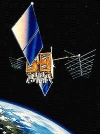
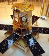
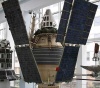
INMARSAT
3F4
I3F4
AOR-W
#24819
(1997-027A) |
Inmarsat I-3 F4 was the
fourth of the third generation Inmarsat satellites.
It was launched in 1997 from Kourou on an Ariane rocket
(V97) to cover the Western Atlantic Ocean Region. It
was finally placed in a geostationary orbit at 54°
West. Its communication system include 22(+11) L-band
transponders (22W power amplifiers) and a C-band uplink. |
June
2nd 1997 |
2400
kg |
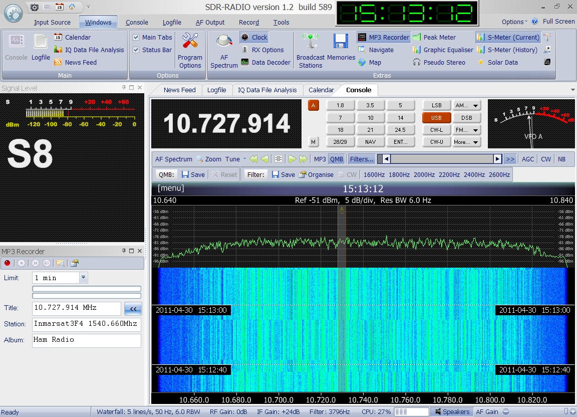
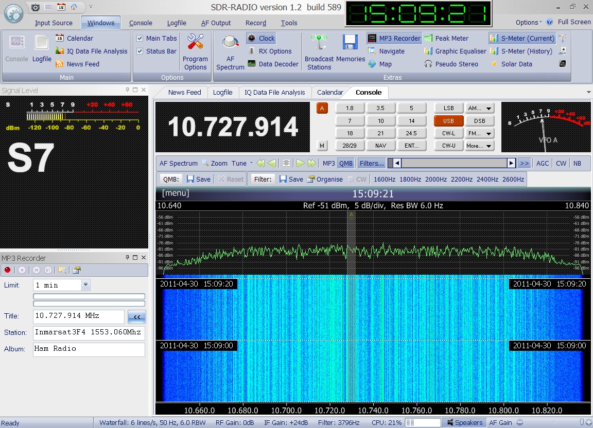
 Enclosed
audio signal was received on April 30th
2011 at 15:13 UTC on 1540.66 MHz by Greg Roberts. It
sounds like noise but at the end of the recording you
can hear it change pitch as the signal shifts. Many
thanks to Greg Roberts for kindly providing this recording. Enclosed
audio signal was received on April 30th
2011 at 15:13 UTC on 1540.66 MHz by Greg Roberts. It
sounds like noise but at the end of the recording you
can hear it change pitch as the signal shifts. Many
thanks to Greg Roberts for kindly providing this recording.
|
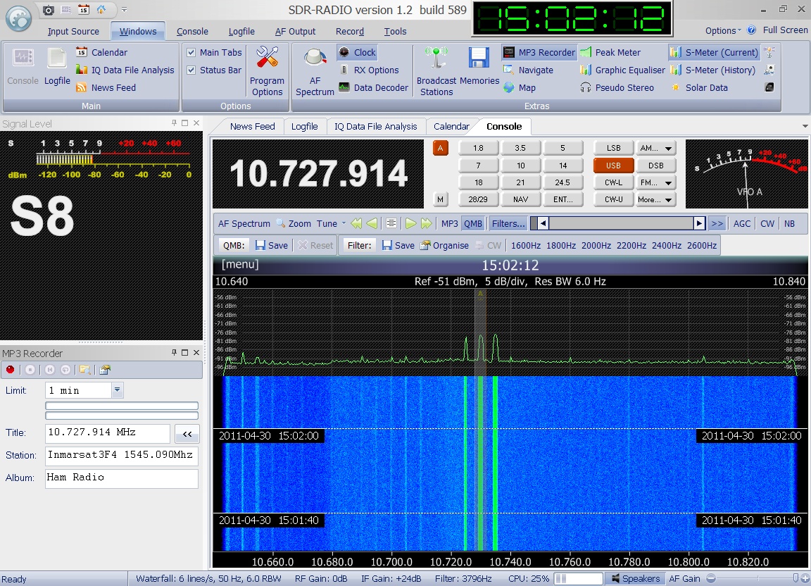
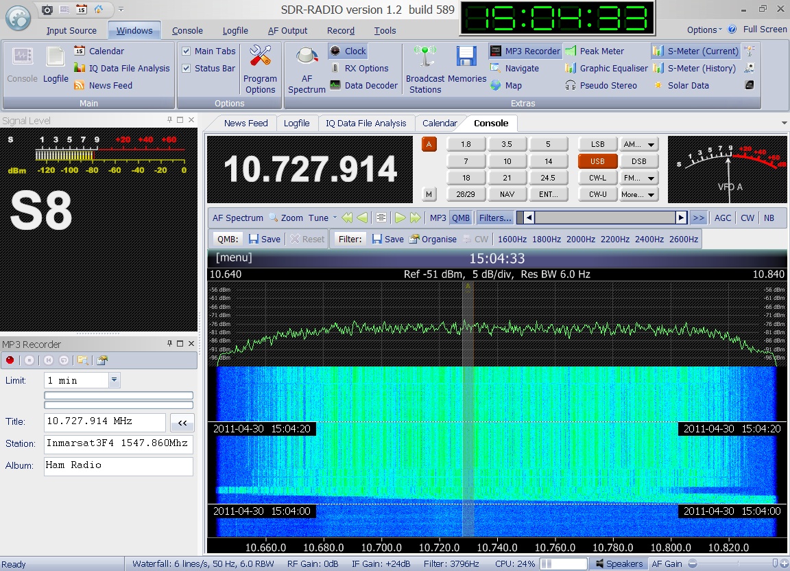
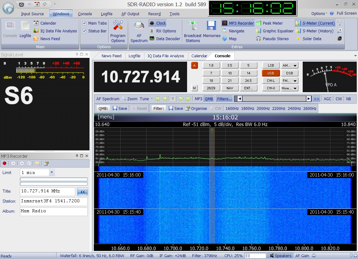
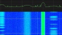
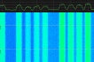
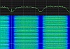
Also on Inmarsat 3F4
many different signals can be found on its transponders
are. Enclosed please find some spectrum plots each of
them being 190kHz wide and taken all by Greg Roberts
on April 30th 2011 around 15:00
UTC.
     |

|
METEOSAT-7
#24932
(1997-049B) |
METEOSAT-7,
a European meteorological satellite, was launched from
the Kourou space center in French Guiana aboard an Ariane
44LP rocket. It was the last member of the 1st
generation of METEOSAT satellites and was first placed
in a geosynchronous orbit at 10.2 deg W. Later Eumetsat
moved METEOSAT-7 to 0° E longitude. The standard
mode of operation was full-disk imagery in 3 channels
every half-hour. The 1691 MHz downlink signal was recorded
by Michael Fletcher OH2AUE on April 12th 2006 at 19:45UTC. |
Sep
2nd 1997 |
3455
kg |
In April
2006 METEOSAT-7 was out of inclination-keeping fuel
and thus it was de-commissioned on June 14th
2006. This marked also the end of almost a quarter of
a century of Meteosat's 1st
generation transmissions. This is the very last transmission
from Meteosat-7 on June 14th
2006 before it was finally shut off. The recording was
kindly provided by Paul Marsh M0EYT. |
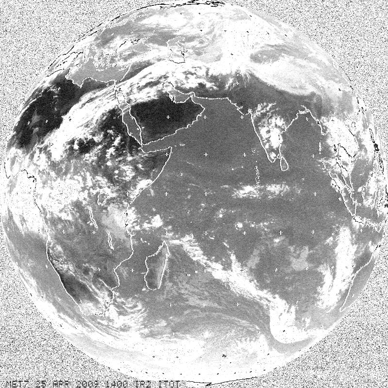
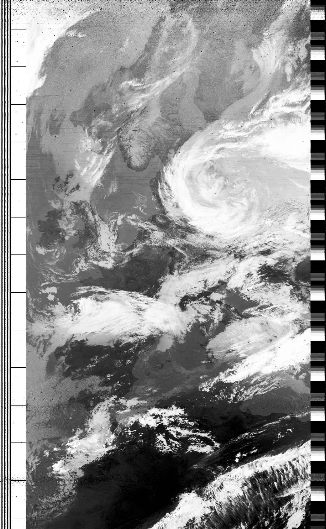
Some time
later it turned out, that the APT transmissions of Meteosat-7
were not  completely
stopped. After the satellite had been moved East to
53°E it continued to transmit APT pictures on 1691,007
MHz in FM modulation. Enclosed audio file was recorded
as well as the associated picture was decoded and kindly
provided on April 25th 2009
by Nils. completely
stopped. After the satellite had been moved East to
53°E it continued to transmit APT pictures on 1691,007
MHz in FM modulation. Enclosed audio file was recorded
as well as the associated picture was decoded and kindly
provided on April 25th 2009
by Nils. |
|
Iridium
43
#25039
(1997-069A) |
The IRIDIUM satellite
system provides worldwide voice and data coverage including
remote areas. It consists of 66 active satellites in
low Earth circular orbits with an altitude of 780km
and an inclination of 86.4°. The communication system
uses a combined FDMA/TDMA approach. The communication
to the terminals is in the frequency range of 1616-1626.5
MHz. Up- and Downlinks to the basestations and gateways
as well as inter-satellite links operate in the frequency
ranges 19.4-19.6 GHz and 29.1-29.3 GHz. Iridium 43 was
part of a strong rocket launch campaign which lasted
a year and a half and had followed a decade of planning
the system. Finally on November 1st
1998 Iridium began commercial operation and was thus
the first global satellite-based personal communication
system supporting handheld devices. |
Nov
9th 1997 |
689
kg |
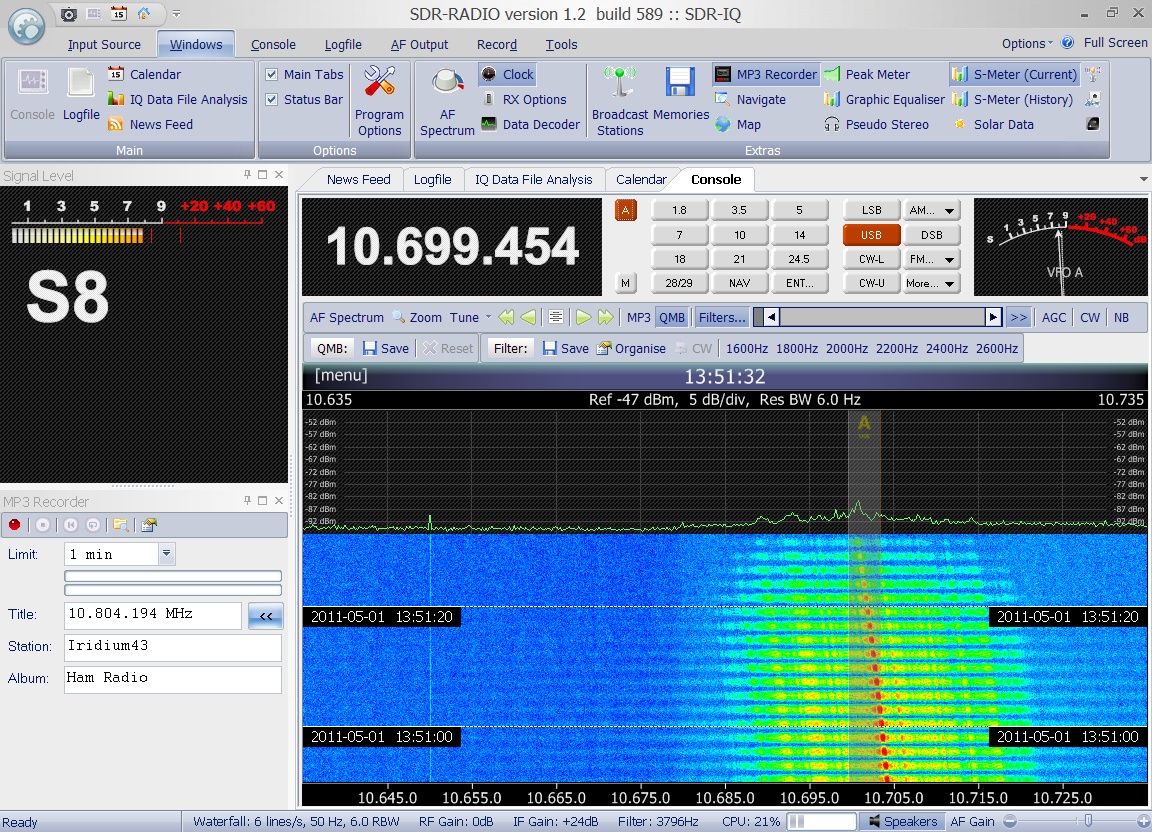
 Enclosed
IRIDIUM signal was received on May 1st
2011 at 13:51 UTC on 1624.880 MHz in SSB by Greg Roberts. Enclosed
IRIDIUM signal was received on May 1st
2011 at 13:51 UTC on 1624.880 MHz in SSB by Greg Roberts.
|

|
ORBCOMM
FM-08 (A4)
#25112
(1997-084A) |
ORBCOMM FM-8 is part
of a commercial venture to provide global messaging
services using a constellation of 26 low-Earth orbiting
satellites. The spacecraft was a circular shaped disk.
Circular panels hinged from each side after launch to
expose solar cells. These panels tilted in one
axis to track the sun and provide 160W electrical power.
FM-08 was launched in a stack of 8 Microstar / Orbcomm
satellites with a Peagasus rocket which was dropped
my an airplane. The deployed spacecraft measured 3.6
m from end to end with 2.3 m span across the circular
disks. VHF telemetry was at 57.6 kbps. The spacecraft
carried 17 data processors and 7 antennas and was designed
to handle 50,000 messages per hour. The long boom was
a 2.6 meter VHF/UHF gateway antenna. Receive: 2400 bps
at 148 - 149.9 MHz. Transmit: 4800 bps at 137 - 138
MHz and 400.05 to 400.15 MHz. The system used X.400
(CCITT 1988) addressing. Message size was 6 to 250 bytes
typical (no maximum). |
Dec
23rd 1997 |
40
kg |
Enclosed
signal from ORBCOMM FM-08 was received on February 15th
2014 at 13:00 UTC on 137.800 MHz in FM by DD1US. |
|
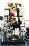
COSMOS 2349
Kometa
#25167
(1998-009A) |
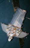
Cosmos
2349 was a Russian military photographic satellite and
part of the Yantar program. More precisely Cosmos
2349 was part of the Kometa series and was launched
by a Soyuz-U rocket from the Baikonur cosmodrome.
 It
provided topographical maps of the US with a resolution
of 2m in accordance with a Russian-American project
called SPIN-2. The pictures were brought back to ground
by a return capsule (see picure to the right). It
provided topographical maps of the US with a resolution
of 2m in accordance with a Russian-American project
called SPIN-2. The pictures were brought back to ground
by a return capsule (see picure to the right).
The
PCM/FM telemetry signal ( 1 sec frame) was received
on 150.3 MHz on March 18th
1998 by Sven Grahn. |
Feb 17th
1998 |
6600 kg |
|
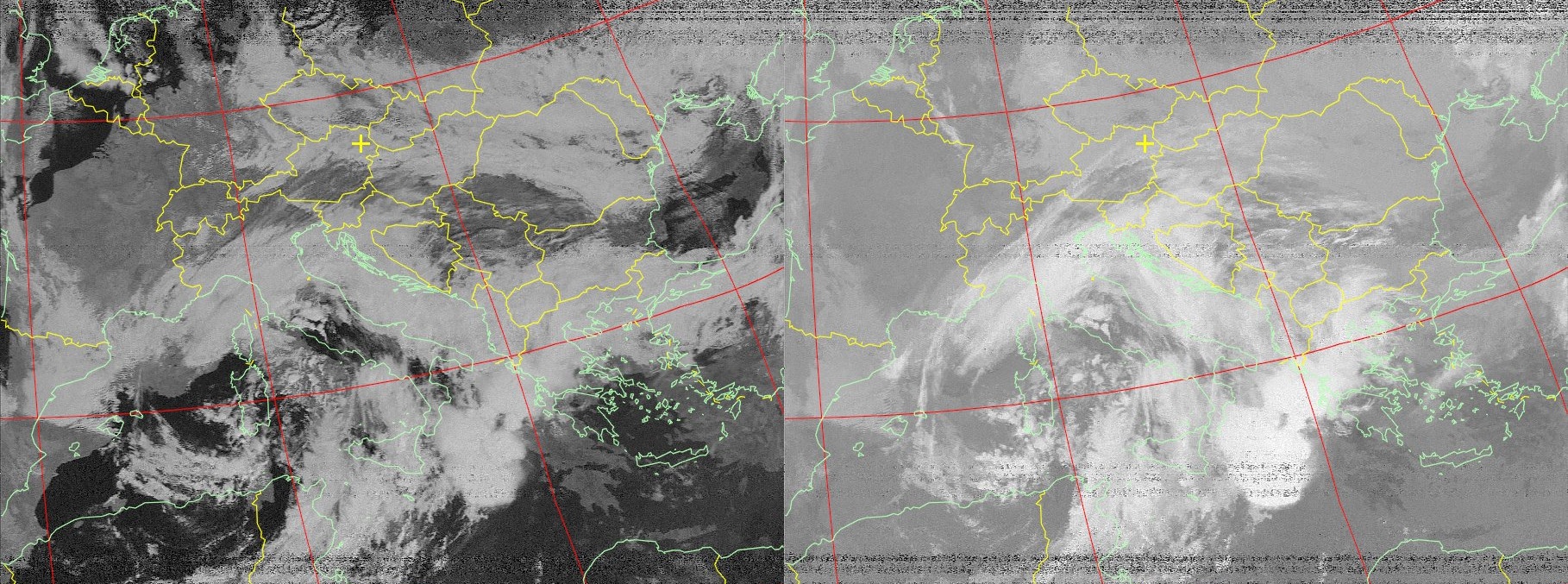
NOAA 15
#25338
(1998-030A) |
NOAA-15
was the first in a series of five satellites called
POES with improved imaging and sounding capabilities.
The audio file was recorded on 137.500 MHz on July 16th
1998 by DD1US. |
May 13th
1998 |
1475 kg |
 During
the year 1998 and then again in summer 2011 I received
a number of APT pictures from NOAA-15. Click on the
picture on the right to have a look at this collection. During
the year 1998 and then again in summer 2011 I received
a number of APT pictures from NOAA-15. Click on the
picture on the right to have a look at this collection.
|
NOAA-15
was still active 10 years later as the recording from
Patrick DK193WN on June 26th
2008 shows. His R2FX receiver was tuned to 137.500 MHz. |
 The
S-Band downlink at 1544.500 MHz was received and recorded
as a spectrum plot by Paul M0YET on October 13th
2007. The
S-Band downlink at 1544.500 MHz was received and recorded
as a spectrum plot by Paul M0YET on October 13th
2007.
|
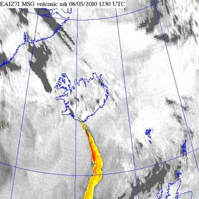
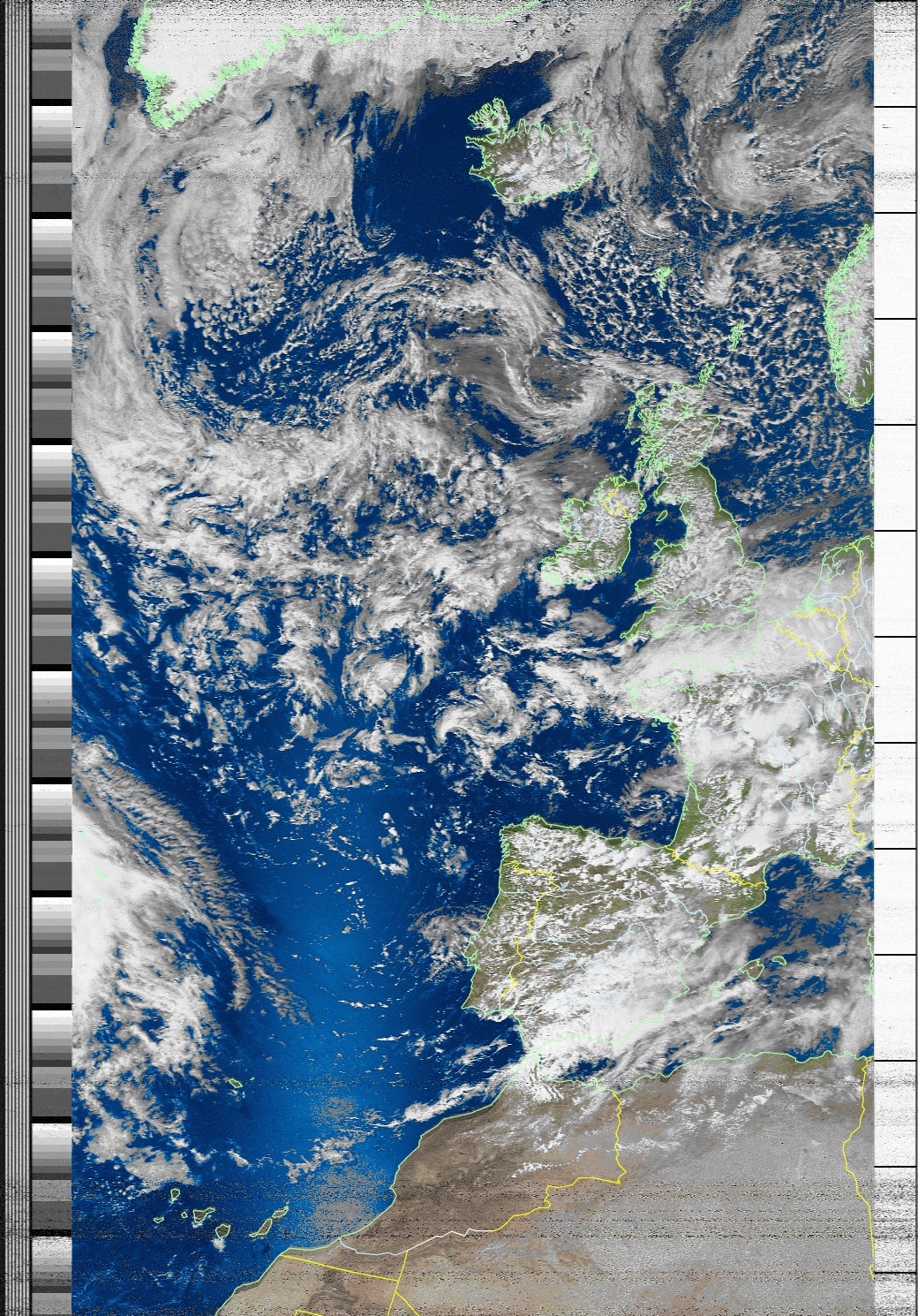
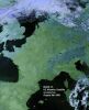
  On
May 8th 2009 Nils received
enclosed APT picture from NOAA-15, which shows nicely
the ash-cloud coming from a volcano on Iceland. The
picture on the right shows the details of the cloud
based on another source. The pictures were kindly provided
by Nils. On
May 8th 2009 Nils received
enclosed APT picture from NOAA-15, which shows nicely
the ash-cloud coming from a volcano on Iceland. The
picture on the right shows the details of the cloud
based on another source. The pictures were kindly provided
by Nils.
|
 Also in
2012 NOAA-15 was still transmitting excellent pictures
like the one enclosed. NOAA-15 was received on 137.620
MHz in FM on May 6th 2012 at
15:16 UTC by DD1US. Also in
2012 NOAA-15 was still transmitting excellent pictures
like the one enclosed. NOAA-15 was received on 137.620
MHz in FM on May 6th 2012 at
15:16 UTC by DD1US.
|
 On April
26th 2018 NOAA-15 had a malfunction
which resulted in a distorted APT transmission on 137.620
MHz. The satellite was recovered later. The audio recording
and image was kindly provided by Egor UB1QBJ. On April
26th 2018 NOAA-15 had a malfunction
which resulted in a distorted APT transmission on 137.620
MHz. The satellite was recovered later. The audio recording
and image was kindly provided by Egor UB1QBJ.
|
 On July
23rd 2019 NOAA-15 had another
malfunction. Apparently it was switching between channels
which resulted in a distorted On July
23rd 2019 NOAA-15 had another
malfunction. Apparently it was switching between channels
which resulted in a distorted  APT
transmission on 137.620 MHz. The satellite was recovered
later. The audio recording and images were kindly provided
by Egor UB1QBJ. APT
transmission on 137.620 MHz. The satellite was recovered
later. The audio recording and images were kindly provided
by Egor UB1QBJ.
|
|
RESURS
O1-N4
RESURS-O1 #4
#25394
(1998-043A) |
RESURS
O1-N4 is a Russian natural resources sensing  satellite
that was launched from Baykonur using a Zenit 2 rocket
to perform ecological and meteorological monitoring.
The transmitted APT picture and the audio file were
received on 137.850 MHz on February 28th
1999 at 10:30 UTC by Mike DK3WN. satellite
that was launched from Baykonur using a Zenit 2 rocket
to perform ecological and meteorological monitoring.
The transmitted APT picture and the audio file were
received on 137.850 MHz on February 28th
1999 at 10:30 UTC by Mike DK3WN. |
July 10th
1998 |
1250 kg |
|
ORBCOMM
FM-25 (C5)
#25479
(1998-053E) |
Orbcomm is a commercial
global wireless data and messaging system. The Orbcomm
System uses low-Earth orbit (LEO) satellites to provide
cost-effective tracking, monitoring and messaging capabilities
to and from anywhere in the world. Similar to two-way
paging or e-mail, the system is capable of sending and
receiving two-way alphanumeric packets of data. These
short, economical messages increase the efficiency of
remote operations by making critical information readily
available, often from areas beyond the geographic and
economic reach of traditional systems.
The Orbcomm constellation
consists of up to 36 small communications satellites
in orbit 825 kilometers above the Earth. The satellites
act as orbiting packet routers built to grab small
data packets from ground sensors or communicators and
relay them through a ground station.
Orbcomm satellites
have also been used for relaying messages from orbit
to the ground from Rubin test satellites. |
Sept.
23rd 1998 |
40
kg |
Enclosed
signal from ORBCOMM FM-25 was received on March 28th
2009 on 137.225 MHz in CW by Patrick DK193WN. Recording
kindly provided by Patrick Hajagos DK193WN. |
|
Afristar
AfriStar 1
#25515
(1998-063A) |
AfriSta was launched
with Ariane 44L from Kourou. It was the first Worldspace
satellite. It was placed into a geostationary orbit
at 21° East. Its mission is to provide digital audio
and multimedia services to emerging and under-served
markets of the world. Its uplink is in X-band and the
downlink is in L-band (1453.384
1490.644 MHz). Its 3 L-band transponders
feature 53 dBW ERIP. |
October
28th 1998 |
1205
kg |
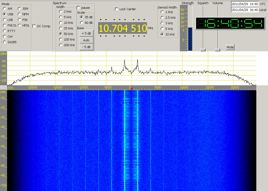
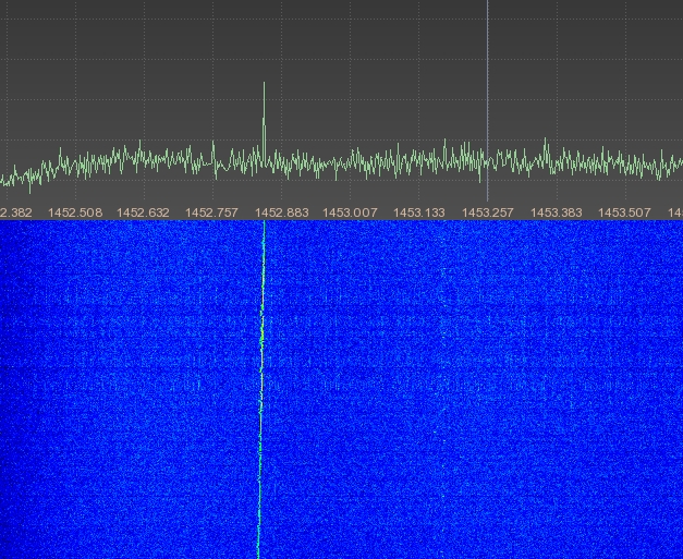
 The TTC
beacon of Afristar-1 is at 1491.7030 MHz. On April 30th
2011 at 16:40 UTC Greg Roberts received one of its sidebands
in USB at 1491.7429 MHz. The TTC
beacon of Afristar-1 is at 1491.7030 MHz. On April 30th
2011 at 16:40 UTC Greg Roberts received one of its sidebands
in USB at 1491.7429 MHz.
|
 This pulsing
carrier of Afristar-1 was found on 1487.884 MHz on April
30th 2011 at 10:28 UTC by Greg
Roberts. This pulsing
carrier of Afristar-1 was found on 1487.884 MHz on April
30th 2011 at 10:28 UTC by Greg
Roberts.
|
 On
February 5th 2012 Matthias
DD1US verified, that Afristar can sill be received in
Central Europe. He received 6 audio cannels. Click on
the receiver picture to the right to get a more detailed
report. On
February 5th 2012 Matthias
DD1US verified, that Afristar can sill be received in
Central Europe. He received 6 audio cannels. Click on
the receiver picture to the right to get a more detailed
report.
|
|
DLR-TUBSAT
TUBSAT-C
#25757
(1999-029B) |
DLR-TUBSAT
was built by TU-Berlini and transmitted telemetry as
well as command data in 1200bd FFSK ASCII on 143.075
MHZ and on 436.075 MHz.
Enclosed signal was received on 436.075
MHz by Maik Hermenau. Recording kindly provided by Maik. |
May 27th
1999 |
45 kg |
|
NAVSTAR 46
USA 145
GPS 2R-3
GPS SVN 46
#25933
(1999-055A) |
NAVSTAR 46 (also
known as USA 145, and GPS 2R-3) was an American navigational
spacecraft of the GPS fleet launched by a Delta 2 rocket
from Cape Canaveral at 13:51 UT. This was the third
of the 21 redesigned 2R series that may eventually replace
the existing GPS fleet. |
Oct.
7th 1999 |
2032
kg |
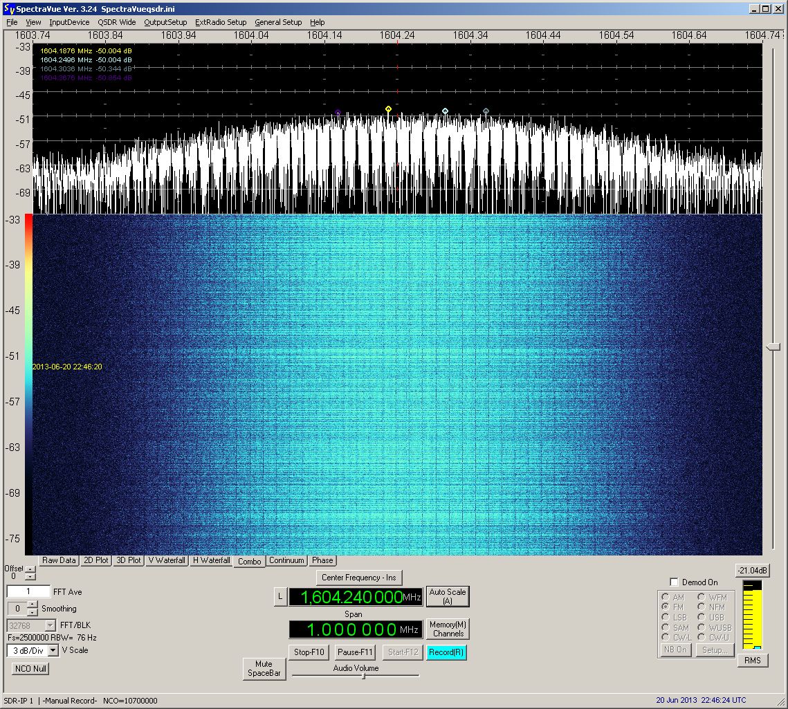
 The S-Band
downlink at 1575.500 MHz was received by Paul M0EYT
on June 20th 2013 at 22:37
UTC. The S-Band
downlink at 1575.500 MHz was received by Paul M0EYT
on June 20th 2013 at 22:37
UTC.
Recording and spectrum plot kindly
provided by Paul Marsh M0EYT. |

|
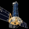
XMM-Newton
Newton
#25889
(1999-066A) |
XMM (X-ray Multimirror
Mission) is a an x-ray telescope containing three mirror
modules each consisting of 58 nested mirrors. The effective
area of the three modules combined is about 6500 sq
cm between 0.1 and 1 keV and about 2000 sq cm at 10
keV. The spatial resolution is about 30 arc-seconds.
The instruments consist of the European (x-ray) Photon
Imaging Cameras (EPIC), the Reflection Grating Spectrometers
(RGS), and the Optical Monitor. Among the goals
for the 10 year lifetime of XMM are: understanding the
diffuse x-ray background, mapping the x-ray emitting
gas in clusters of galaxies, unbiased surveys of galaxies
and of stars, diagnostic studies of accreting binary
stars, temporal spectroscopic studies of AGN's and spectral
studies of supernove remnants in nearby galaxies. |
Dec
10th 1999 |
3800 kg |
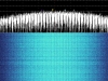
 The
S-Band downlink on 2224,92 MHz of XMM-Newton was received
and enclosed FFT plot was generated in May 2014 by Milen
Rangelov. The
S-Band downlink on 2224,92 MHz of XMM-Newton was received
and enclosed FFT plot was generated in May 2014 by Milen
Rangelov.
|
|
IMAGE
NASA ID 166
#26113
(2000-017A) |
IMAGE (Imager for Magnetopause-to-Aurora
Global Exploration) is a MIDEX class mission, selected
by NASA in 1996, to study the global response of the
Earth's magnetosphere to changes in the solar wind.
On December 18th
2005, after 5.8 years of successful operations, IMAGE's
telemetry signals were not received during a routine
pass. In the next years NASA did not receive any signals
and gave up this mission.
On January 20th
2018 a Radio Amateur, Scott Tilley VE7TIl, rediscovered
the signal of the lost satellite after more than 12
years. Based on his input NASA confirmed that the satellite
is back in good health is now trying to reestablish
the communication IMAGE. |
Mar.
25th 2000 |
536
kg |
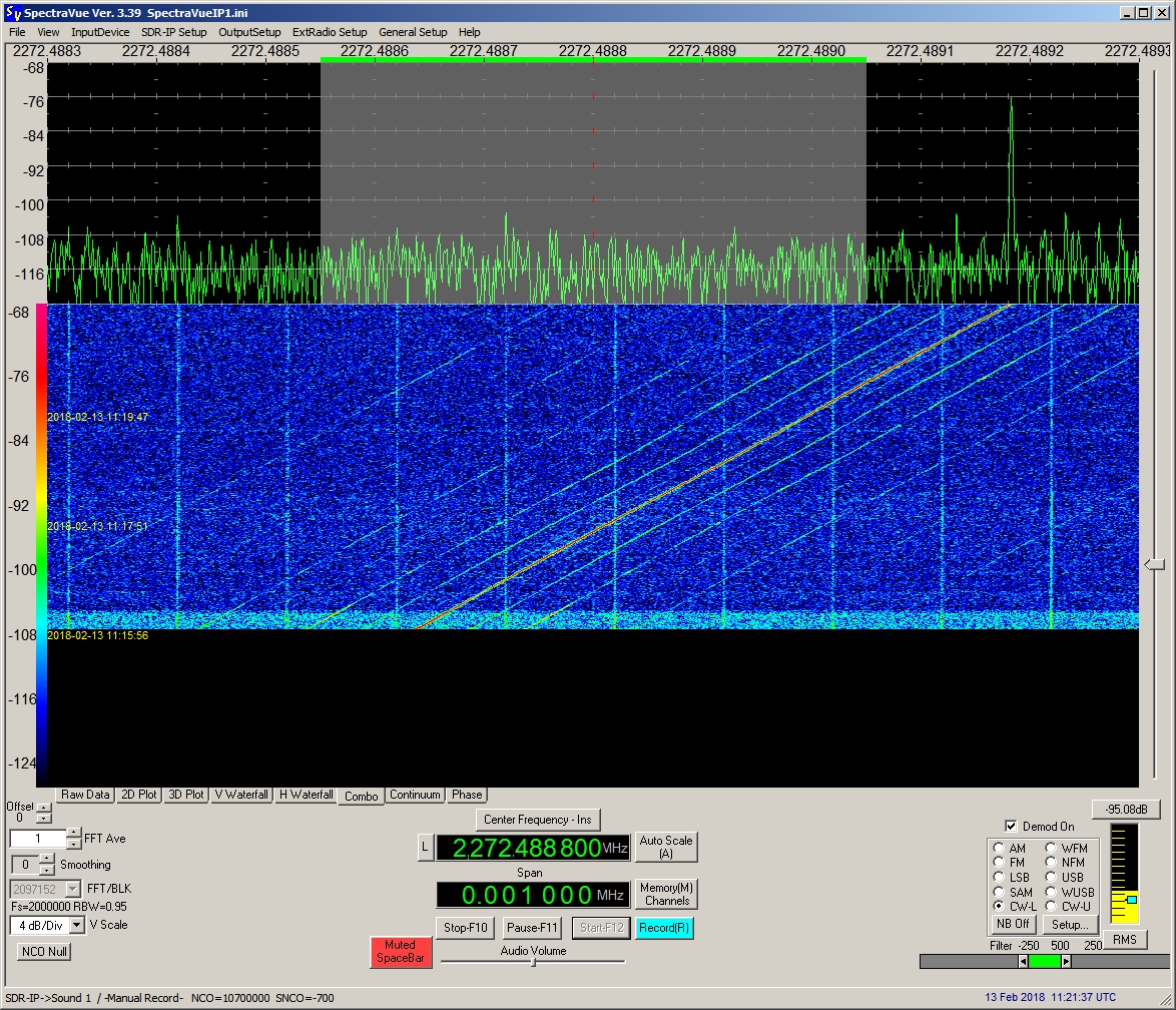
 The S-Band
downlink on 2272,50 MHz of IMAGE was received on February
13th 2018 The S-Band
downlink on 2272,50 MHz of IMAGE was received on February
13th 2018  at
11:15 UTC by DD1US. Modulation sidebands can be seen
on enclosed FFT plots. at
11:15 UTC by DD1US. Modulation sidebands can be seen
on enclosed FFT plots. 
|
 On May
26th 2018 Edgar DF2MZ observed
the signal from IMAGE when it suddenly appeared after
the satellite came out of a longer eclipse. Recording
and spectrum plot kindly provided by Edgar Kaiser DF2MZ. On May
26th 2018 Edgar DF2MZ observed
the signal from IMAGE when it suddenly appeared after
the satellite came out of a longer eclipse. Recording
and spectrum plot kindly provided by Edgar Kaiser DF2MZ.
|
|
ZY-2A
ZY
2A
PRC 44
#26481
(2000-050A) |
Zhangguo
Ziyuan 2 (China Resource 2), also known as PRC 44 and
as ZY 2 is a Chinese remote sensing spacecraft that
was launched by a Long March 4B rocket from Taiyuan
launch center into a sun synchronous orbit. Transmissions
were on 179.951 MHz and a CW signal on 479.869 MHz.
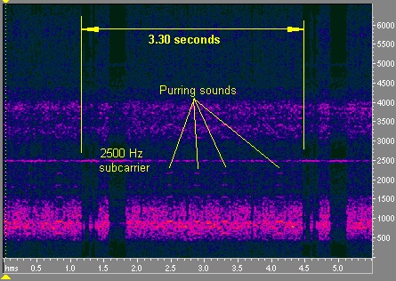
 Enclosed
3.3 sec telemetry frame was received on 179.971 MHz
on September 24th 2000 at 10:10
UTC by Sven Grahn. He also provided enclosed analysis
of this signal. Enclosed
3.3 sec telemetry frame was received on 179.971 MHz
on September 24th 2000 at 10:10
UTC by Sven Grahn. He also provided enclosed analysis
of this signal. |
Sept. 1st
2000 |
? kg |
|
MEGSAT-1
#26545
(2000-057A) |
Megsat-1 is an Italian
environment monitoring satellite and was launched by
a Dnepr rocket from Baikonur into a circular orbit with
64.6° inclination and about 642km height. Megsat-1
was launched together with 4 other microsatellites which
were Tiungsat-1, Unisat, Saudisat-1A and Saudisat-1B.
Megsat-1 followed Megsat-0 which had been launched on
April 28th 1999 in order to
offer 64kbps Store and Forward communications with a
downlink at 137.905 MHz. It carries two scientific payloads
to measure UV emissions from the aurora borealis to
determine their correlation with solar activity in oxygen
lines and to measure near-UV night sky background emissions. |
Sept
26th 2000 |
56 kg |
The audio
file enclosed was received on 137.905 MHz in FM on April
13th 2009 around 07:43 UTC
by Sven Grahn. |
The audio
file enclosed was received on 137.905 MHz on April 14th
2009 around 13:00 UTC by Nils. |
Megsat-1
was still active after 10 years of operation. Enclosed
weak but discernable signal was received on October
15th 2010 at 07:37 UTC on 137.904
MHz in FM by Patrick DK193WN. Recording kindly provided
by Patrick. |
|
EROS-A1
#26631
(2000-079A) |
EROS A1 (Earth Resources
Observation Satellite) is an Israeli photo-reconnaissance
satellite that was launched by a START 1 rocket from
the new launch site at Svobodni in Siberia. It was the
third launch from that site. The START 1 rocket is a
modified SS-25. The satellite is 3-axis stabilized and
carries a black and white high resolution (1.8 m) CCD
camera, to obtain images (with terrain width of 12.6
km) of locations chosen by Israeli military or world-wide
commercial clients, and downlink them to one of the
14 ground stations. |
Dec
5th 2000 |
250 kg |
 The
S-Band downlink on 2295 MHz of EROS-A1 was received
and enclosed FFT plot was generated in April 2014 by
Milen Rangelov. The
S-Band downlink on 2295 MHz of EROS-A1 was received
and enclosed FFT plot was generated in April 2014 by
Milen Rangelov.
|
|
PROBA
PROBA 1
#26598
(2001-049B) |
PROBA 1 (PRoject for
On-Board Autonomy, 1) is a Belgian minisatellite that
was launched by a PSLV-C3 rocket by ISRO in India into
a 553 km × 677 km orbit with
98° inclination. It is operated by ESA and carries
a radiation detector, a debris impact monitoring instrument,
and a remote sensing camera for performance assessment
(resolution 18m). |
Nov
22nd 2001 |
94
kg |
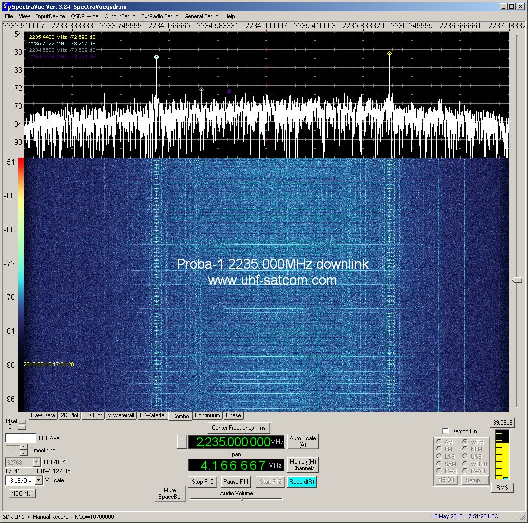
  PROBA
has an S-Band downlink at 2235 MHz which was received
by Paul Marsh on May 10th 2013 at 17:54 UTC. Audio recording
and spectrum plots kindly provided by Paul Marsh M0EYT. PROBA
has an S-Band downlink at 2235 MHz which was received
by Paul Marsh on May 10th 2013 at 17:54 UTC. Audio recording
and spectrum plots kindly provided by Paul Marsh M0EYT.
|
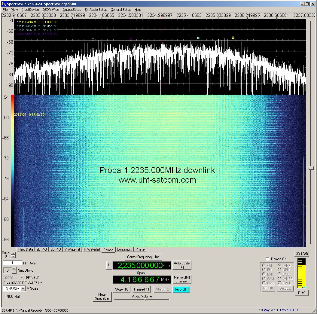
 The
S-Band downlink on 2235 MHz of Proba-1 was received
and enclosed FFT plot was generated in May 2014 by Milen
Rangelov. The
S-Band downlink on 2235 MHz of Proba-1 was received
and enclosed FFT plot was generated in May 2014 by Milen
Rangelov.
|
|
MAROC-TUBSAT
#26704
(2001-056D)
|
Maroc-Tubsat
is a Moroccan microsatellite which was launched by a
Zenit rocket from Baikonur. Its primary mission was
the test of a 3D attitude control system.
Enclosed
morse-code signal was received on 144.1 MHz on January
23rd 2002 by Sven Grahn. |
Dec 10th
2001 |
47 kg |

|
GONETS D1-7
GONETS 12
#27058
(2001-058D) |
Gonets (Messenger) 12
is a Russian civilian communications spacecraft that
was launched by a Tsiklon 3 rocket from Plesetsk at
04:09 UT on 28 December 2001. Gonets
satellites were the civilian derivate
of the military Strela-3 satellite system. Their purpose
is to locate and report natural and man-made environmental
disasters around the world, and to relay messages from/to
mobile telephones. The Gonets satellites were capable
of store-dump communications on 2-3 channels in the
2004-400 MHz band with a transmitter output power
of 10 W. Data transmission rates available include
2.4 kbits/s, 9.6 kbit/s, and 64 kbit/s with an onboard
storage capacity of 8 Mbytes. |
Dec
28th 2001 |
233
kg |
 GONETS
D1-7 was received by Roland Proesch DF3LZ on January
2nd 2014 on 263.080 MHz in
USB. GONETS
D1-7 was received by Roland Proesch DF3LZ on January
2nd 2014 on 263.080 MHz in
USB.
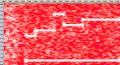
The spectrogam shows the multitone sigal. Sound
file kindly provided by Roland Proesch DF3LZ.
|
|
NOAA
17
NOAA M
#27453
(2002-032A) |
One of
the fourth-generation of operational, polar orbiting,
meteorological satellites. Enclosed audio file was recorded
on March 19th 2008 at 11:45UTC
in FM on 137.620 MHz by DD1US. |
Jun
24th 2002 |
1457
kg |
 The
APT picture to the right from Noaa 17 was received on
October 20th 2002 on 137.620
MHz in FM by DD1US. The
APT picture to the right from Noaa 17 was received on
October 20th 2002 on 137.620
MHz in FM by DD1US.
|
 This
sound file and the corresponding APT picture were received
by Patrick DK193WN on Sept 14th
2008 on 137.620 MHz from NOAA-17. This
sound file and the corresponding APT picture were received
by Patrick DK193WN on Sept 14th
2008 on 137.620 MHz from NOAA-17.
|
On October
22nd 2010 Patrick received
enclosed signal from NOAA-17 which contains only half
a picture and the rest looks like a barcode. This is
due to a degradation of the AVHRR scan motor in Noaa
17 which became critical February 19th
2010. Recording was kindly provided by Patrick Hajagos. |
 Mid
of 2011 NOAA 17 was still exhibiting the same problem
as can be seen in the picture enclosed. Recorded on
August 16th 2011 at 09:59 UTC
by DD1US. Mid
of 2011 NOAA 17 was still exhibiting the same problem
as can be seen in the picture enclosed. Recorded on
August 16th 2011 at 09:59 UTC
by DD1US.
|
NOAA-17 was decommissioned
on April 10th 2013 at 12:17
UTC. |

|
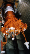
COSMOS
2391
KOSMOS 2391
Strela-3 #132
#27465
(2002-036B) |
Cosmos 2391 was launched
together with Cosmos 2390 by a Cosmos-3M rocket from
Plesetsk at 06:36 UT on July 8th2002.
COSMOS 2391 is used for store-dump communications by
Russian government and military. |
Jul
8th 2002 |
200
kg |
 COSMOS
2391 was received by Roland Proesch DF3LZ on December
26th 2013 at 15:30 UTC on 244.5125
MHz in USB. The spectrogam shows the ID of the satellite.
Sound file kindly provided by Roland Proesch DF3LZ. COSMOS
2391 was received by Roland Proesch DF3LZ on December
26th 2013 at 15:30 UTC on 244.5125
MHz in USB. The spectrogam shows the ID of the satellite.
Sound file kindly provided by Roland Proesch DF3LZ.
|

|
COSMOS
2395
KOSMOS 2395
GLONASS 792
Uragan #81
#27619
(2002-060C) |
GLONASS (Globalnaya
Navigationnaya Sputnikovaya Sistema, Global Orbiting
Navigation Satellite System) is a Soviet space-based
navigation system comparable to the American GPS system,
which consists of Uragan spacecraft. The operational
system contains 21 satellites in 3 orbital planes, with
3 on-orbit spares. GLONASS provides 100 meters accuracy
with its C/A (deliberately degraded) signals and 10-20
meter accuracy with its P (military) signals.
The Uragan spacecraft
are 3-axis stabilized, nadir pointing with dual solar
arrays.
The payload consists
of L-Band navigation signals in 25 channels separated
by 0.5625 MHz intervals in 2 frequency bands: 1602.5625
- 1615.5 MHz and 1240 - 1260 MHz. EIRP 25 to 27 dBW.
Right hand circular polarized. On-board caesium clocks
provide time accuracy to 1000 nanoseconds.
Cosmos 2395 is one
of three Glonass fleet spacecraft that was launched
by a Proton-K rocket from Baikonur at 07:38 UTC on December
25th 2002.
They extend the current, depleted fleet of nine spacecraft
to 12, which will grow further to a fleet of 18 spacecraft
by 2004, and to 24 by 2005. The original fleet had 24
spacecrafts in the 1980s. |
Dec
25th 2002 |
1415
kg |
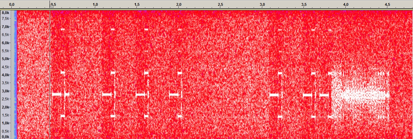
 COSMOS
2395 was received by Paul M0EYT on June 20th
2013 at 22:46 UTC on 1604.240 MHz. COSMOS
2395 was received by Paul M0EYT on June 20th
2013 at 22:46 UTC on 1604.240 MHz.
Recording and Spectrum plot kindly
provided by Paul Marsh M0EYT. |
|
CORIOLIS
#27640
(2003-001A) |
Coriolis is an American
(DOD) spacecraft that was launched by a Titan 2 rocket
from Vandenberg AF. The 395 kg, 1,174 W, 3.0 m diameter,
6.9 m high, triaxially-stabilized spacecraft carried
82 kg of fuel and 340 kg of instruments. The two instruments
are WindSat to monitor ocean surface wind speed and
direction from space, and SMEI (solar mass ejection
imager) to to
detect disturbances in the solar wind by means of imaging
scattered light from the free electrons in the plasma
of the solar wind. To do this three CCD cameras observe
sections of the sky of size 60 by 3 degree. Data
will be stored onboard and downlinked to dedicated ground
stations in x-band. Reported downlink frequencies in
S-band are 2215.5 MHz, 2221.5 MHz and
2242.5 MHz. |
Jan
6th 2003 |
395
kg |
 The
S-Band downlink on 2215.5 MHz of CORIOLIS was received
and enclosed FFT plot was generated in May 2014 by Milen
Rangelov. The
S-Band downlink on 2215.5 MHz of CORIOLIS was received
and enclosed FFT plot was generated in May 2014 by Milen
Rangelov.
|
|
SORCE
#27651
(2003-004A) |
SORCE
(SOlar Radiation and Climate Experiment) is an American
(NASA) Sun-Earth Connection satellite that was launched
on January 25th 2003
at 20:13 UTC by a Pegasus XL rocket released from a
L-1011 cargo aircraft flying out of Cape Canaveral.
It is to measure solar irradiance in a number of wavelength-bands
through three spectrometers and a photometer. |
Jan
25th 2003 |
315
kg |
 The
S-Band downlink on 2273.5 MHz of SORCE was received
and enclosed FFT plot was generated in May 2014 by Milen
Rangelov. The
S-Band downlink on 2273.5 MHz of SORCE was received
and enclosed FFT plot was generated in May 2014 by Milen
Rangelov.
|
|
MIMOSA
#27841
(2003-031B) |
MIMOSA
(MIcroMeasurements Of Satellite Accelerations) is a
Czech minisatellite which is nearly spherical with 28
sides and carries a microaccelerometer to monitor the
atmospheric density profile by sensing the atmospheric
drag. CW transmission was recorded on 137.143 MHz by
Mike D. Kenny. |
Jun 30th
2003 |
66 kg |
|
IRS-P6
Resourcesat 1
#28051
(2003-046A) |
IRS
P6, also known as Resourcesat 1, is an Indian remote
sensing and photo-imaging spacecraft that was launched
by a PSLV-C5 rocket from Sriharikota in southeast India
into a 817km polar sun-synchronous orbit. The satellite
carries high resolution imaging instruments to monitor
agricultural, land, and water resources. |
Oct
17th 2003 |
1360
kg |
 The
S-Band downlink on 2250 MHz of IRS-P6 was received and
enclosed FFT plot was generated between March and May
2014 by Milen Rangelov. The
S-Band downlink on 2250 MHz of IRS-P6 was received and
enclosed FFT plot was generated between March and May
2014 by Milen Rangelov.
|
|
DMSP
F-16
DMSP 5D3-F16
USA172
#28054
(2003-048A) |
DMSP F16 (USA 172)
was launched by a Titan 2 rocket from Vandenberg AFB.
The Defense Meteorological Satellite Program (DMSP)
is a Department of Defense (DoD) program run by the
Air Force Space and Missle Systems Center (SMC). The
program designs, builds, launches, and maintains satellites
monitoring the meteorological, oceanographic, and solar-terrestrial
physics environments. Each DMSP satellite has a 101
minute, sun-synchronous near-polar orbit at an altitude
of 830km above the surface of the earth. |
Oct
18th 2003 |
1200
kg |
 The
S-Band downlink on 2222.5 MHz of DMSP F-16 was received
and enclosed FFT plot was generated in May 2014 by Milen
Rangelov. The
S-Band downlink on 2222.5 MHz of DMSP F-16 was received
and enclosed FFT plot was generated in May 2014 by Milen
Rangelov.
|
|
Molniya 1-93
Molniya
1-T
#28163
2004-005A |
Russian
Military Communications satellite. Highly elliptical
Molniya orbit.
Enclosed signal of its sweeping carrier
was received on 1000.44 MHz on July 26th
2006 by Sven Grahn. |
Feb 18th
2004 |
2000 kg |
|
UNISAT-3
#28373
(2004-025H) |
UNISAT-3
is an Italian, scientific microsatellite designed to
test solar cells in the space environment, to measure
magnetic fields to compute the satellite altitude and
to test radio communications. 9600 Baud GMSK signal
recorded on 435.230 MHz during its first days after
launch by Brian Hougesen OZ1SKY. |
Jun 29th
2004 |
12 kg |


|
SICH-1M
OKEAN-O1 #9)
#28505
(2004-052A) |
Sich 1M is a Russo-Ukrainian
Earth surveying mini-satellite that was launched by
a Tsyklon 3 rocket from Plesetsk at 11:20 UT on December
24th 2004. Unfortunately SICH-1M
did not reach the final orbit due to a malfunction of
the 3rd stage of the rocket.
It carried imaging instruments to survey the surface
environment and locate natural disasters. Sich is the
Ukrainian name for owl. Downlinks were at 137.400 MHz,
466.5 MHz and 460.03 MHz. SICH-1M stopped operations
on August 8th 2005 and re-entered. |
Dec
24th 2004 |
2223
kg |
 This
sound file and the corresponding APT picture were received
by Alex in Zwickau on March 3rd
2005 on 137.400 MHz from SICH-1M. Alex used a R2FX receiver
and a turnstile antenna. This
sound file and the corresponding APT picture were received
by Alex in Zwickau on March 3rd
2005 on 137.400 MHz from SICH-1M. Alex used a R2FX receiver
and a turnstile antenna.
|
|
IRS-P5
Cartosat-1
#25758
(2005-017A) |
CartoSat-1 or IRS
P5 (Indian Remote Sensing Satellite) was built by ISRO
and is mainly intended for cartographic applications.
It is the eleventh satellite built in the Indian Remote
Sensing (IRS) satellite series and was launched into
a 618 km high polar Sun Synchronous Orbit (SSO) by PSLV-C6.
It carries two Panchromatic (PAN) cameras that take
black and white stereoscopic pictures of the earth in
the visible region of the electromagnetic spectrum.
The swath covered by these high resolution PAN cameras
is 30 km and their spatial resolution is 2.5 meters.
It facilitates the generation of accurate three-dimensional
maps. The images taken by CartoSat-1 cameras are compressed,
encrypted, formatted and transmitted to the ground stations
where the images are reconstructed from the data received. |
May
5th 2005 |
1560
kg |
 The
S-Band downlink on 2245.7 MHz of IRS-P5 was received
and enclosed FFT plot was generated between March and
May 2014 by Milen Rangelov. The
S-Band downlink on 2245.7 MHz of IRS-P5 was received
and enclosed FFT plot was generated between March and
May 2014 by Milen Rangelov.
|
|
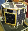
HAMSAT
VUSat
OSCAR-52
#28650
(2005-017B) |
HAMSAT
is an Indian (ISRO) microsatellite. It relays amateur
VHF radio communications. You can find more information
on the Ham Radio experiments in the respective
section. There seems to be also a non-amateur-radio
PCM/BPSK transmission which was recorded on 137.175
MHz by Mike D. Kenny. |
May
5th 2005 |
42.5
kg |
HAMSAT was not received
for quite some time until Mike D. Kenny identified the
satellite again in October 2017 with an unmodulated
carrier (sometimes pulses at about 4 times a second)
on 137.149 MHz. |
|
NOAA
18
NOAA N
#28654
(2005-18A) |
The APT
downlink frequencies are VTX-1: 137.100 MHz and VTX-2:
137.9125 MHz. Noaa-18 switched from VTX-2 to VTX-1 on
January 4th 2006 and back from
VTX-1 to VTX-2 on July 20th
2006 at 13:20 UTC. Later, on Thursday, August 16th 2007
at 14:46 UTC it was again switched back to VTX-1 and
since then transmits on 137.100 MHz. The beacon frequency
is 137.350 MHz. Enclosed audio file was recorded on
March 19th 2008 at 10:40UTC in FM (BW only 15 kHz) by
DD1US. |
Jun
24th 2005 |
1457
kg |
This
APT signal was received with less noise by Alan Banks. |
 This
sound file and the corresponding APT picture were received
by Patrick DK193WN on May 3rd
2008 on 137.100 MHz from NOAA-18. This
sound file and the corresponding APT picture were received
by Patrick DK193WN on May 3rd
2008 on 137.100 MHz from NOAA-18.
|
 During
my summer vacation 2011 I received NOAA 18 multiple
times. You can find a number of pictures following the
link associated with the picture to the right. Here
is a sound file recorded on 137.9125 MHz on August 19th
2011 at 13:09 UTC by DD1US. During
my summer vacation 2011 I received NOAA 18 multiple
times. You can find a number of pictures following the
link associated with the picture to the right. Here
is a sound file recorded on 137.9125 MHz on August 19th
2011 at 13:09 UTC by DD1US.
|
 Also in
2012 NOAA-18 was still transmitting excellent pictures
like the one enclosed. NOAA-18 was received on 137.9125
MHz in FM on May 5th 2012 at
14:44 UTC by DD1US. Also in
2012 NOAA-18 was still transmitting excellent pictures
like the one enclosed. NOAA-18 was received on 137.9125
MHz in FM on May 5th 2012 at
14:44 UTC by DD1US.
|
|
Mozhayets
5
Sinah-1
Roskosmos
RS-25
#28898
(2005-043G) |
Mozhayets 5 = Sinah-1
is an educational technology satellite carrying a laser
communications experiment. It is based on the Strela
1M2 platform. It is reported that Mozhayets 5 failed
to detach from the upper stage of the Kosmos 3M launcher.
Therefore its NORAD number is identical to the launcher
(and thus RUBIN-5 see below). |
Oct
27th 2005 |
160
kg |
Sinah-1
includes a russian CW beacon transmitting on 435.325
MHz with the callsign RS-25. This beacon was recorded
by Mike DK3WN on Oct. 29th
2005 at 23:22 UTC. |
Sinah-1
is also transmitting digital data in FM on 435.325 MHz.
Recorded by Maik Hermenau. |
|
RUBIN-5
SAFIR-S
#28898
(2005-043G) |
The launch of Mozhayets
5 also includes 2 experiments from Germany. Rubin-5
is a technology/communications payload using the ORBCOMM
system. It remained intentionally attached to the rocket
final stage (it is part of the adapter used to deploy
the other satellites). It included the AATiS SAFIR-S
amateur transponder and the ESA ASOLANT solar-powered
GPS antenna experiment. SAFIR-S transmitted on 2401.9
MHz. |
Oct 27th
2005 |
64 kg |
|
INMARSAT
4F2
I4F2
#28899
(2005-044A) |
Inmarsat I-4 F2 was the
second of the fourth generation Inmarsat satellites
built by Astrium. It was launched in 2005 on a Zenit
3SL rocket to cover the Indian Ocean Region. It was
finally placed in a geostationary orbit at 25.3°
East. The total power of the satellite is 13 kWatts
and it uses 200 spot beams to provide video, data, video-conference
and internet services. It supports the Broadband Global
Area Network (B-GAN). |
Nov
8th 2005 |
5958
kg |
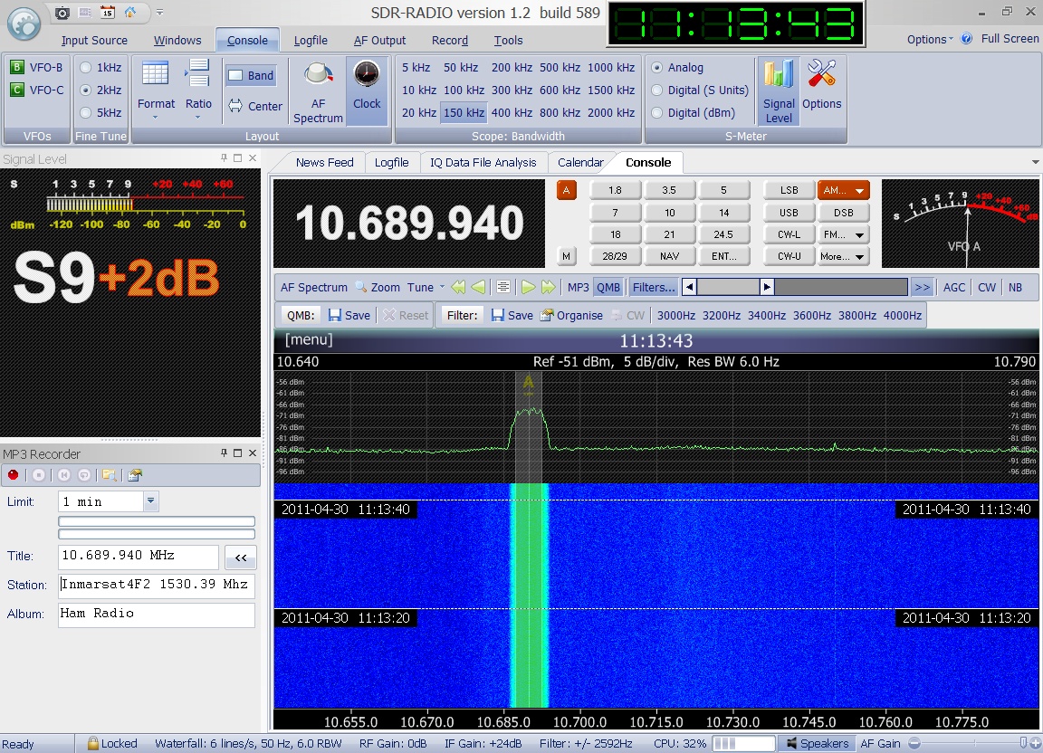
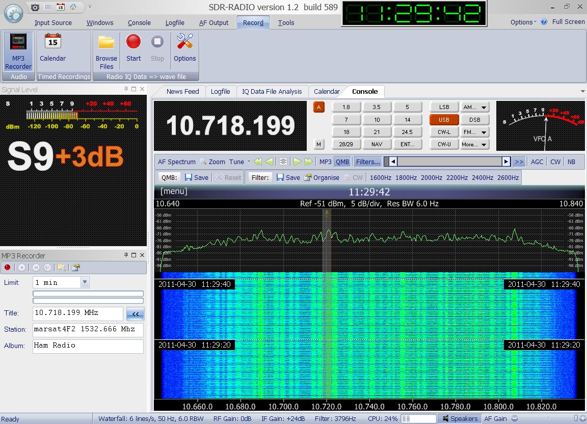
 Enclosed
audio signal and associated spectrum plot was received
on 1530.390 MHz in USB and recorded by Greg Roberts
on April 30th 2011 at 11:13
UTC. Enclosed
audio signal and associated spectrum plot was received
on 1530.390 MHz in USB and recorded by Greg Roberts
on April 30th 2011 at 11:13
UTC.
|
 Enclosed
audio signal and associated spectrum plot was received
on 1532.0375 MHz in USB and recorded by Greg Roberts
on April 30th 2011 at 11:18
UTC. Enclosed
audio signal and associated spectrum plot was received
on 1532.0375 MHz in USB and recorded by Greg Roberts
on April 30th 2011 at 11:18
UTC.
|
 Enclosed
audio signal and associated spectrum plot was received
on 1532.660 MHz in USB and recorded by Greg Roberts
on April 30th 2011 at 11:29
UTC. Enclosed
audio signal and associated spectrum plot was received
on 1532.660 MHz in USB and recorded by Greg Roberts
on April 30th 2011 at 11:29
UTC.
|
 Enclosed
audio signal and associated spectrum plot was received
on 1534.060 MHz in USB and recorded by Greg Roberts
on April 30th 2011 at 11:35
UTC. Enclosed
audio signal and associated spectrum plot was received
on 1534.060 MHz in USB and recorded by Greg Roberts
on April 30th 2011 at 11:35
UTC.
|
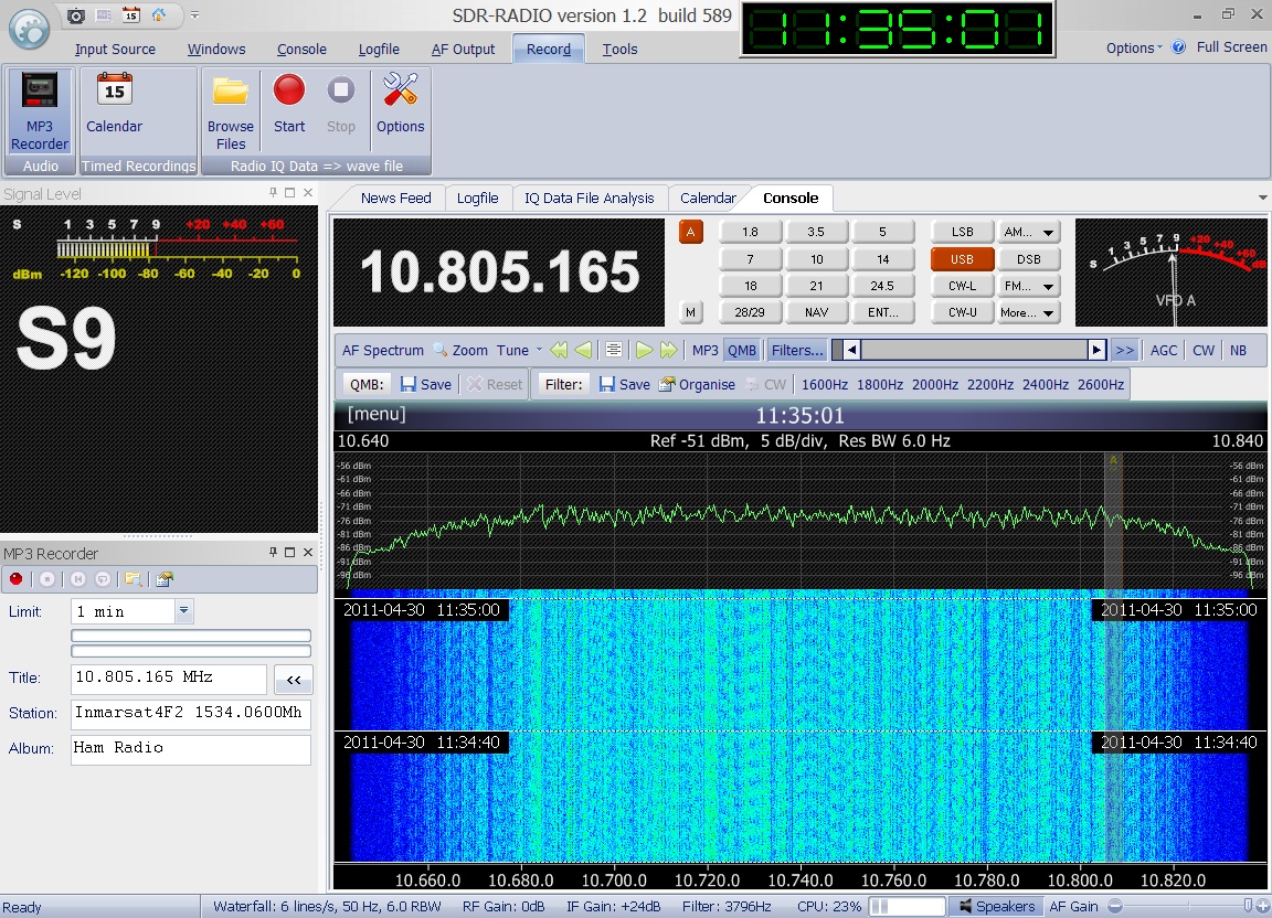
 Enclosed
audio signal and associated spectrum plot was received
on 1535.865 MHz in USB and recorded by Greg Roberts
on April 30th 2011 at 11:44
UTC. Enclosed
audio signal and associated spectrum plot was received
on 1535.865 MHz in USB and recorded by Greg Roberts
on April 30th 2011 at 11:44
UTC.
|
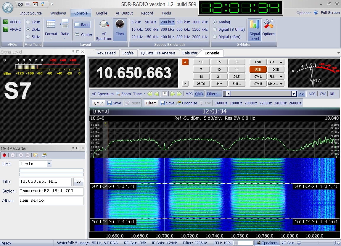
 Enclosed
audio signal and associated spectrum plot was received
on 1541.700 MHz in USB and recorded by Greg Roberts
on April 30th 2011 at 12:01
UTC. Enclosed
audio signal and associated spectrum plot was received
on 1541.700 MHz in USB and recorded by Greg Roberts
on April 30th 2011 at 12:01
UTC.
|
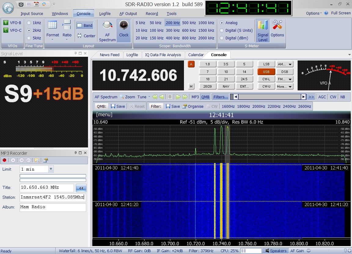
 Enclosed
audio signal and associated spectrum plot was received
on 1545.085 MHz in USB and recorded by Greg Roberts
on April 30th 2011 at 12:41
UTC. Enclosed
audio signal and associated spectrum plot was received
on 1545.085 MHz in USB and recorded by Greg Roberts
on April 30th 2011 at 12:41
UTC.
|
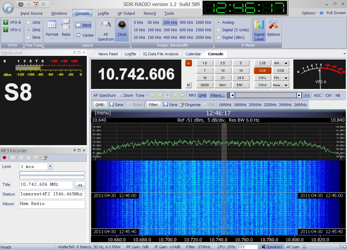
 Enclosed
audio signal and associated spectrum plot was received
on 1546.465 MHz in USB and recorded by Greg Roberts
on April 30th 2011 at 12:46
UTC. Enclosed
audio signal and associated spectrum plot was received
on 1546.465 MHz in USB and recorded by Greg Roberts
on April 30th 2011 at 12:46
UTC.
|
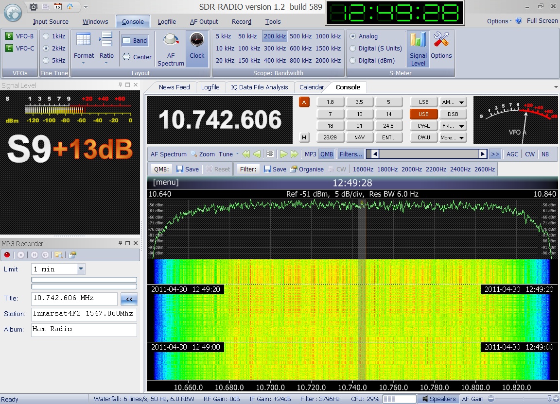
 Enclosed
audio signal and associated spectrum plot was received
on 1547.860 MHz in USB and recorded by Greg Roberts
on April 30th 2011 at 12:49
UTC. Enclosed
audio signal and associated spectrum plot was received
on 1547.860 MHz in USB and recorded by Greg Roberts
on April 30th 2011 at 12:49
UTC.
|
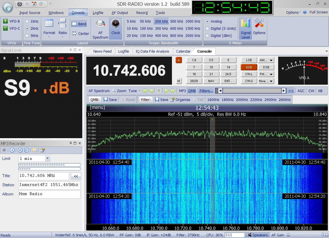
 Enclosed
audio signal and associated spectrum plot was received
on 1551.465 MHz in USB and recorded by Greg Roberts
on April 30th 2011 at 12:54
UTC. Enclosed
audio signal and associated spectrum plot was received
on 1551.465 MHz in USB and recorded by Greg Roberts
on April 30th 2011 at 12:54
UTC.
|
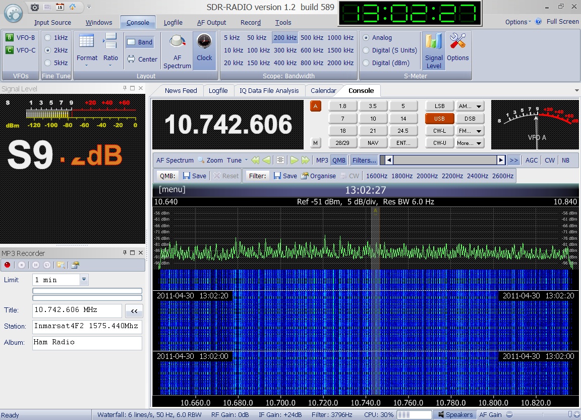
 Enclosed
audio signal and associated spectrum plot was received
on 1575.440 MHz in USB and recorded by Greg Roberts
on April 30th 2011 at 12:54
UTC. Enclosed
audio signal and associated spectrum plot was received
on 1575.440 MHz in USB and recorded by Greg Roberts
on April 30th 2011 at 12:54
UTC.
|

|
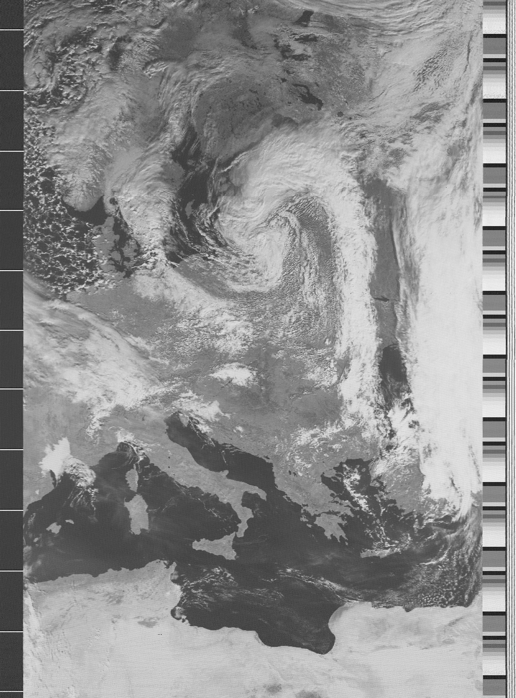
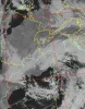
MSG 2
METEOSAT-9
#28912
(2005-049B) |
MSG 2 (Meteosat
Second Generation 2) is a European (ESA) geostationary
weather satellite, with operational control by the EUMETSAT
organization. The craft was renamed Meteosat 9 after
it was moved to is geostationary final position at 0.0°
longitude . It is spin-stabilized and carries two main
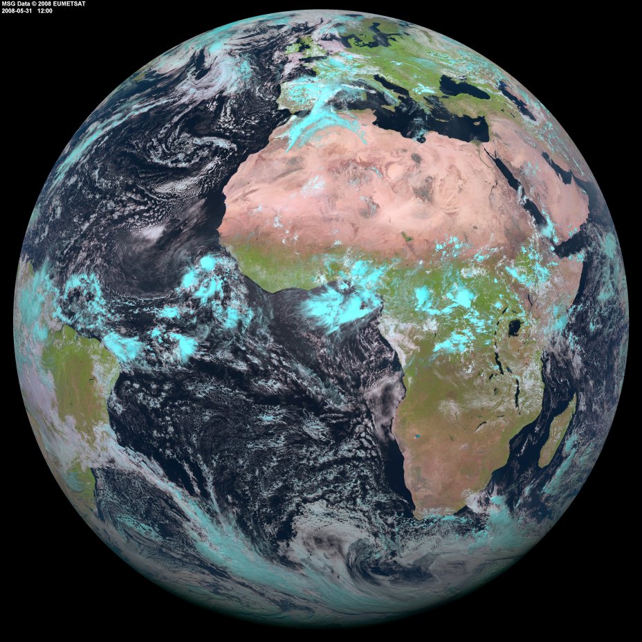
instruments. SEVIRI (Spinning Enhanced Visible and InfraRed
Imager)  will
provide images taken in four visible and eight infrared
channels every 15 minutes, at a resolution of 1 km in
visible light and 3 km in infrared. The false colour
picture enclosed shows the full Earth disk and was recorded
on May 31st 2008 at 12:00 UTC.
Copyright MSG_Data@2008_Eumetsat. Thanks to Alan Banks
for kindly providing the picture. will
provide images taken in four visible and eight infrared
channels every 15 minutes, at a resolution of 1 km in
visible light and 3 km in infrared. The false colour
picture enclosed shows the full Earth disk and was recorded
on May 31st 2008 at 12:00 UTC.
Copyright MSG_Data@2008_Eumetsat. Thanks to Alan Banks
for kindly providing the picture. |
Dec 21st
2005 |
2000 kg |
Picture |
Object
name
#NORAD |
Description |
Launch
Date |
Weight |